SmogRank / Episodes / United Kingdom
United Kingdom, Belgium and France, April 2025
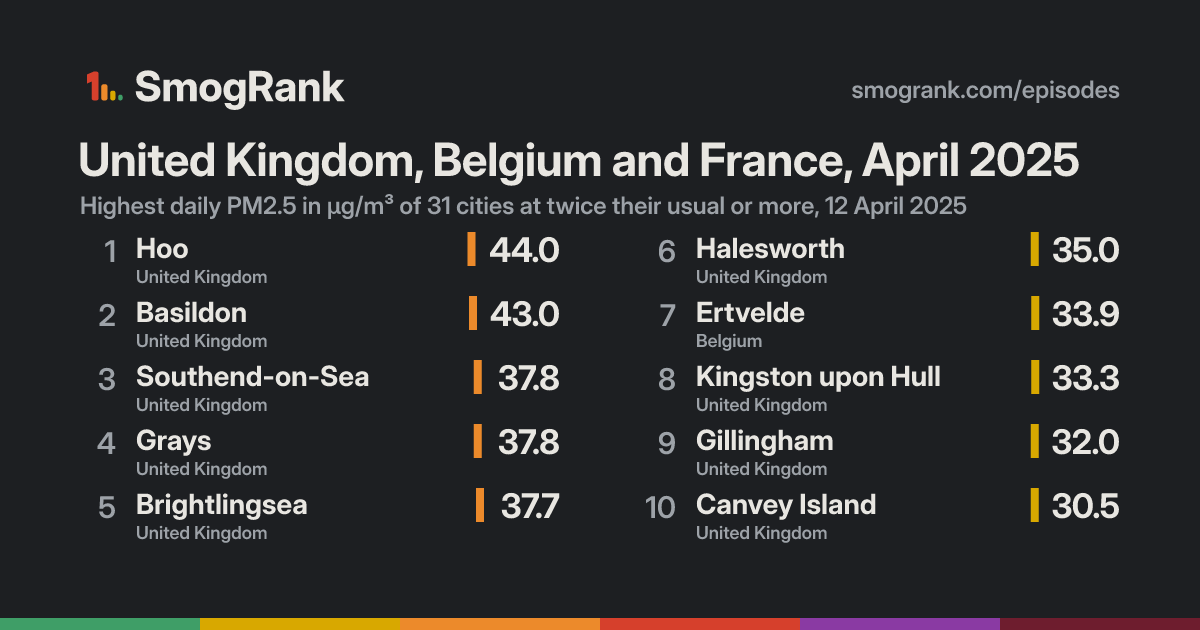
For 1 day, on 12 April 2025, 31 cities in the United Kingdom, Belgium and France had PM2.5 at least twice their usual for the time of year. The worst reading was Hoo, England, United Kingdom: 44.0 µg/m³ on 12 April, about 6.3× its usual 7.0. Ended 12 April.
Likely smoke from fires Fires were detected within 300 km of the city on 58% of the counted city-days. Satellites see crop, field and forest fires alike, so this doesn't say which burned.
Cities reached 31 in 3 countries
Days 1 12 April 2025
Worst day 12 April 31 cities counted
Furthest above usual 6.3× Hoo
Day by day
Play 12 April 31 cities at twice their usual or more
Veurne Boulogne-sur-Mer Damme Maidstone Maldegem Meulebeke Béthune Menen Kortrijk Lille Roubaix Arras London 's-Gravenzande Tournai Douai Eastbourne Market Deeping Borehamwood Maassluis The Hague Horley Seaford Spijkenisse Amiens Denain Schiedam Hayes Valenciennes Noordwijkerhout Rotterdam Beveren Dieppe Brighton Melsele Hillegom Kapellen Antwerp Ridderkerk Velserbroek Willebroek Mons Worthing Storrington Grimbergen Zwanenburg Brussels Badhoevedorp Northampton Mechelen Wormer Zaanstad Scunthorpe Farnborough Zaventem Breda Amsterdam Purmerend Lopik Rixensart Reading Breukelen Maarssen Leicester IJsselstein Jumet Charleroi Nottingham Utrecht Aarschot Medemblik Tilburg Mansfield Oxford Doncaster Pickering Mol Portsmouth Couvin York Namur Coventry Royal Leamington Spa Champion Derby Rotherham Chesterfield Gingelom Sheffield Revin Waalre Andover Burton upon Trent Eindhoven Barneveld Andenne Barnsley Southampton Houthalen Hasselt Lunteren Hamois Leeds Genk Swindon Dewsbury Birmingham Flémalle-Haute Middlesbrough Thornaby-on-Tees Nijmegen Ans High Peak Hartlepool Bradford Marche-en-Famenne Liège Cannock Cheltenham Christchurch Venray Worcester Stoke-on-Trent Ashton-under-Lyne Gloucester Cheadle Hulme Westbury Heerlen Kollum Venlo Manchester Kaldenkirchen Aachen Telford Bastogne Nettetal Vielsalm Crewe Middlewich Irlam Roetgen Jülich Mönchengladbach Bristol Warrington Blackburn Titz Chepstow Groningen Krefeld Jüchen Wesel Shrewsbury Niederzier Wigan Street Preston Duisburg Speke Borken Enschede Düsseldorf Oberhausen Wrexham Ratingen Newport Pulheim Sinnersdorf Bottrop Liverpool Essen Köln Leverkusen Gelsenkirchen Blackpool Wuppertal Hattingen Emden Honiton Lingen Norderney Bonn Datteln Dortmund Hagen Schwerte Münster Cwmafan Lüdenscheid Unna Briton Ferry Neuwied Newton Abbot Swansea Bendorf Friesoythe Koblenz Höhr-Grenzhausen Bösel Osnabrück Barnstaple Soest Wilhelmshaven Netphen Oldenburg Limburg an der Lahn Plymouth Warstein Saltash Wiesbaden Mainz Luton Izegem Zwijndrecht Knokke-Heist Calais Dunkirk Stabroek Zelzate Lochristi Koksijde Gent Roeselare Ertvelde Peterborough Gillingham Bexley Sheringham Canvey Island Immingham Burwell Dunholme Clacton-on-Sea Norwich Newmarket Kingston upon Hull Grays Basildon Southend-on-Sea Brightlingsea Halesworth Hoo On the map: 50 fire detections.
9 Apr 10 11 12 13 14 15 Every measured city in the area, coloured by its PM2.5 that day; a dark ring marks a city at twice its usual or more. Bars: cities counted each day, coloured by their median level. Choose a day or press play; without JavaScript, the days link to that day's world ranking. Fires, seen Heat satellites detected that day (via NASA FIRMS); bigger and glowing means more detections in the area. Farm burning and other fires count too, not only wildfires.Under the cities, for each UTC day: fires satellites detected (via NASA FIRMS), smoke NOAA analysts traced and volcanic ash warnings for aircraft. They show what was in the air, not that it caused the readings.
Fires: NASA FIRMS (VIIRS). Traced smoke: NOAA Hazard Mapping System. Volcanic ash: aviation ash warnings (SIGMETs) via NOAA's Aviation Weather Center.
How it spread
Hoo Hoo, 9 April: 5.8 µg/m³ Hoo, 10 April: 8.2 µg/m³ Hoo, 11 April: 18.1 µg/m³ Hoo, 12 April: 44.0 µg/m³, 6.3× its usual 7.0 Hoo, 13 April: 10.2 µg/m³ Hoo, 14 April: 6.4 µg/m³ Hoo, 15 April: 17.6 µg/m³ Basildon Basildon, 9 April: 10.7 µg/m³ Basildon, 10 April: 9.8 µg/m³ Basildon, 11 April: 21.2 µg/m³ Basildon, 12 April: 43.0 µg/m³, 5.1× its usual 8.5 Basildon, 13 April: 12.8 µg/m³ Basildon, 14 April: 10.7 µg/m³ Basildon, 15 April: 19.5 µg/m³ Southend-on-Sea Southend-on-Sea, 9 April: 6.0 µg/m³ Southend-on-Sea, 10 April: 7.6 µg/m³ Southend-on-Sea, 11 April: 18.4 µg/m³ Southend-on-Sea, 12 April: 37.8 µg/m³, 6.0× its usual 6.3 Southend-on-Sea, 13 April: 10.1 µg/m³ Southend-on-Sea, 14 April: 6.4 µg/m³ Southend-on-Sea, 15 April: 15.9 µg/m³ Grays Grays, 9 April: 8.7 µg/m³ Grays, 10 April: 7.7 µg/m³ Grays, 11 April: 16.2 µg/m³ Grays, 12 April: 37.8 µg/m³, 5.0× its usual 7.5 Grays, 13 April: 9.2 µg/m³ Grays, 14 April: 6.2 µg/m³ Grays, 15 April: 12.3 µg/m³ Brightlingsea Brightlingsea, 9 April: 5.2 µg/m³ Brightlingsea, 10 April: 6.7 µg/m³ Brightlingsea, 11 April: 19.4 µg/m³ Brightlingsea, 12 April: 37.7 µg/m³, 6.1× its usual 6.2 Brightlingsea, 13 April: 11.3 µg/m³ Brightlingsea, 14 April: 8.3 µg/m³ Brightlingsea, 15 April: 16.7 µg/m³ Halesworth Halesworth, 9 April: 4.3 µg/m³ Halesworth, 10 April: 5.7 µg/m³ Halesworth, 11 April: 21.7 µg/m³ Halesworth, 12 April: 35.0 µg/m³, 6.3× its usual 5.6 Halesworth, 13 April: 12.5 µg/m³ Halesworth, 14 April: 6.7 µg/m³ Halesworth, 15 April: 17.4 µg/m³ Ertvelde Ertvelde, 9 April: 17.2 µg/m³ Ertvelde, 10 April: 9.9 µg/m³ Ertvelde, 11 April: 17.3 µg/m³ Ertvelde, 12 April: 33.9 µg/m³, 3.6× its usual 9.4 Ertvelde, 13 April: 12.8 µg/m³ Ertvelde, 14 April: 6.1 µg/m³ Ertvelde, 15 April: 9.8 µg/m³ Kingston upon Hull Kingston upon Hull, 9 April: 8.2 µg/m³ Kingston upon Hull, 10 April: 14.5 µg/m³ Kingston upon Hull, 11 April: 17.8 µg/m³ Kingston upon Hull, 12 April: 33.3 µg/m³, 5.0× its usual 6.6 Kingston upon Hull, 13 April: 9.1 µg/m³ Kingston upon Hull, 14 April: 5.6 µg/m³ Kingston upon Hull, 15 April: 12.0 µg/m³ Gillingham Gillingham, 9 April: 8.2 µg/m³ Gillingham, 10 April: 7.5 µg/m³ Gillingham, 11 April: 14.5 µg/m³ Gillingham, 12 April: 32.0 µg/m³, 3.7× its usual 8.6 Gillingham, 13 April: 10.3 µg/m³ Gillingham, 14 April: 7.0 µg/m³ Gillingham, 15 April: 12.2 µg/m³ Canvey Island Canvey Island, 9 April: 7.8 µg/m³ Canvey Island, 10 April: 6.3 µg/m³ Canvey Island, 11 April: 13.3 µg/m³ Canvey Island, 12 April: 30.5 µg/m³, 4.2× its usual 7.3 Canvey Island, 13 April: 29.4 µg/m³ Canvey Island, 14 April: 6.5 µg/m³ Canvey Island, 15 April: 14.1 µg/m³ Lochristi Lochristi, 9 April: 17.9 µg/m³ Lochristi, 10 April: 11.9 µg/m³ Lochristi, 11 April: 19.9 µg/m³ Lochristi, 12 April: 29.2 µg/m³, 3.4× its usual 8.7 Lochristi, 13 April: 13.7 µg/m³ Lochristi, 14 April: 6.3 µg/m³ Lochristi, 15 April: 10.4 µg/m³ Dunkirk Dunkirk, 9 April: 6.0 µg/m³ Dunkirk, 10 April: 6.7 µg/m³ Dunkirk, 11 April: 17.3 µg/m³ Dunkirk, 12 April: 29.2 µg/m³, 3.2× its usual 9.0 Dunkirk, 13 April: 14.2 µg/m³ Dunkirk, 14 April: 8.3 µg/m³ Dunkirk, 15 April: 16.6 µg/m³ Newmarket Newmarket, 9 April: 9.6 µg/m³ Newmarket, 10 April: 6.2 µg/m³ Newmarket, 11 April: 13.3 µg/m³ Newmarket, 12 April: 29.1 µg/m³, 4.8× its usual 6.1 Newmarket, 13 April: 24.1 µg/m³ Newmarket, 14 April: 6.7 µg/m³ Newmarket, 15 April: 12.3 µg/m³ Burwell Burwell, 9 April: 6.4 µg/m³ Burwell, 10 April: 7.5 µg/m³ Burwell, 11 April: 19.3 µg/m³ Burwell, 12 April: 29.1 µg/m³, 4.5× its usual 6.4 Burwell, 13 April: 24.1 µg/m³ Burwell, 14 April: 6.7 µg/m³ Burwell, 15 April: 12.3 µg/m³ Roeselare Roeselare, 9 April: 15.3 µg/m³ Roeselare, 10 April: 10.6 µg/m³ Roeselare, 11 April: 17.4 µg/m³ Roeselare, 12 April: 29.1 µg/m³, 3.5× its usual 8.4 Roeselare, 13 April: 13.0 µg/m³ Roeselare, 14 April: 7.1 µg/m³ Roeselare, 15 April: 11.4 µg/m³ Clacton-on-Sea Clacton-on-Sea, 9 April: 6.2 µg/m³ Clacton-on-Sea, 10 April: 5.4 µg/m³ Clacton-on-Sea, 11 April: 12.5 µg/m³ Clacton-on-Sea, 12 April: 29.0 µg/m³, 4.6× its usual 6.3 Clacton-on-Sea, 13 April: 27.1 µg/m³ Clacton-on-Sea, 14 April: 7.2 µg/m³ Clacton-on-Sea, 15 April: 13.7 µg/m³ Norwich Norwich, 9 April: 3.6 µg/m³ Norwich, 10 April: 5.3 µg/m³ Norwich, 11 April: 17.4 µg/m³ Norwich, 12 April: 28.8 µg/m³, 4.8× its usual 6.0 Norwich, 13 April: 11.7 µg/m³ Norwich, 14 April: 5.2 µg/m³ Norwich, 15 April: 15.5 µg/m³ Zelzate Zelzate, 9 April: 14.2 µg/m³ Zelzate, 10 April: 8.7 µg/m³ Zelzate, 11 April: 16.6 µg/m³ Zelzate, 12 April: 28.5 µg/m³, 3.4× its usual 8.3 Zelzate, 13 April: 11.9 µg/m³ Zelzate, 14 April: 5.9 µg/m³ Zelzate, 15 April: 10.3 µg/m³ Knokke-Heist Knokke-Heist, 9 April: 5.4 µg/m³ Knokke-Heist, 10 April: 6.1 µg/m³ Knokke-Heist, 11 April: 14.5 µg/m³ Knokke-Heist, 12 April: 28.2 µg/m³, 3.1× its usual 9.0 Knokke-Heist, 13 April: 13.9 µg/m³ Knokke-Heist, 14 April: 7.4 µg/m³ Knokke-Heist, 15 April: 13.8 µg/m³ Sheringham Sheringham, 9 April: 3.5 µg/m³ Sheringham, 10 April: 8.8 µg/m³ Sheringham, 11 April: 22.9 µg/m³ Sheringham, 12 April: 28.1 µg/m³, 4.2× its usual 6.7 Sheringham, 13 April: 12.4 µg/m³ Sheringham, 14 April: 4.6 µg/m³ Sheringham, 15 April: 17.5 µg/m³ Bexley Bexley, 9 April: 10.5 µg/m³ Bexley, 10 April: 8.1 µg/m³ Bexley, 11 April: 14.4 µg/m³ Bexley, 12 April: 27.3 µg/m³, 4.0× its usual 6.9 Bexley, 13 April: 22.9 µg/m³ Bexley, 14 April: 7.3 µg/m³ Bexley, 15 April: 11.6 µg/m³ Immingham Immingham, 9 April: 7.1 µg/m³ Immingham, 10 April: 11.7 µg/m³ Immingham, 11 April: 15.8 µg/m³ Immingham, 12 April: 27.1 µg/m³, 4.4× its usual 6.1 Immingham, 13 April: 6.2 µg/m³ Immingham, 14 April: 4.0 µg/m³ Immingham, 15 April: 9.4 µg/m³ Gent Gent, 9 April: 17.4 µg/m³ Gent, 10 April: 11.0 µg/m³ Gent, 11 April: 15.9 µg/m³ Gent, 12 April: 27.1 µg/m³, 3.5× its usual 7.8 Gent, 13 April: 11.2 µg/m³ Gent, 14 April: 5.3 µg/m³ Gent, 15 April: 9.0 µg/m³ Peterborough Peterborough, 9 April: 5.4 µg/m³ Peterborough, 10 April: 8.1 µg/m³ Peterborough, 11 April: 15.9 µg/m³ Peterborough, 12 April: 26.9 µg/m³, 3.7× its usual 7.3 Peterborough, 13 April: 8.3 µg/m³ Peterborough, 14 April: 4.6 µg/m³ Peterborough, 15 April: 11.7 µg/m³ Calais Calais, 9 April: 6.9 µg/m³ Calais, 10 April: 6.9 µg/m³ Calais, 11 April: 15.5 µg/m³ Calais, 12 April: 26.8 µg/m³, 3.2× its usual 8.4 Calais, 13 April: 16.6 µg/m³ Calais, 14 April: 8.6 µg/m³ Calais, 15 April: 21.4 µg/m³ Koksijde Koksijde, 9 April: 8.3 µg/m³ Koksijde, 10 April: 7.9 µg/m³ Koksijde, 11 April: 15.5 µg/m³ Koksijde, 12 April: 26.7 µg/m³, 3.5× its usual 7.7 Koksijde, 13 April: 12.7 µg/m³ Koksijde, 14 April: 8.1 µg/m³ Koksijde, 15 April: 11.8 µg/m³ Izegem Izegem, 9 April: 16.4 µg/m³ Izegem, 10 April: 10.0 µg/m³ Izegem, 11 April: 18.4 µg/m³ Izegem, 12 April: 26.7 µg/m³, 2.8× its usual 9.6 Izegem, 13 April: 15.3 µg/m³ Izegem, 14 April: 6.2 µg/m³ Izegem, 15 April: 10.6 µg/m³ Dunholme Dunholme, 9 April: 7.0 µg/m³ Dunholme, 10 April: 13.7 µg/m³ Dunholme, 11 April: 18.4 µg/m³ Dunholme, 12 April: 25.2 µg/m³, 4.6× its usual 5.5 Dunholme, 13 April: 6.0 µg/m³ Dunholme, 14 April: 4.6 µg/m³ Dunholme, 15 April: 9.7 µg/m³ Zwijndrecht Zwijndrecht, 9 April: 13.7 µg/m³ Zwijndrecht, 10 April: 12.2 µg/m³ Zwijndrecht, 11 April: 19.3 µg/m³ Zwijndrecht, 12 April: 25.2 µg/m³, 3.0× its usual 8.5 Zwijndrecht, 13 April: 11.6 µg/m³ Zwijndrecht, 14 April: 5.7 µg/m³ Zwijndrecht, 15 April: 7.9 µg/m³ Stabroek Stabroek, 9 April: 11.8 µg/m³ Stabroek, 10 April: 10.7 µg/m³ Stabroek, 11 April: 20.4 µg/m³ Stabroek, 12 April: 25.1 µg/m³, 3.4× its usual 7.3 Stabroek, 13 April: 12.1 µg/m³ Stabroek, 14 April: 5.3 µg/m³ Stabroek, 15 April: 8.5 µg/m³ Luton Luton, 9 April: 7.5 µg/m³ Luton, 10 April: 10.8 µg/m³ Luton, 11 April: 17.3 µg/m³ Luton, 12 April: 25.0 µg/m³, 2.3× its usual 10.8 Luton, 13 April: 10.1 µg/m³ Luton, 14 April: 4.7 µg/m³ Luton, 15 April: 11.3 µg/m³ 9 Apr 10 11 12 13 14 15 Every counted city, in the order the episode reached them, 3 days before to 3 after. Each square is a day, coloured by that day's PM2.5; outlined: at twice the city's usual or more. Good 0–50
Moderate 51–100
Unhealthy for sensitive groups 101–150
Unhealthy 151–200
Very unhealthy 201–300
Hazardous 301+
Every city it reached
City Days Highest Usual Above usual
Hoo England, United Kingdom 1 12 April 7.0 6.3× Halesworth England, United Kingdom 1 12 April 5.6 6.3× Brightlingsea England, United Kingdom 1 12 April 6.2 6.1× Southend-on-Sea England, United Kingdom 1 12 April 6.3 6.0× Basildon England, United Kingdom 1 12 April 8.5 5.1× Grays England, United Kingdom 1 12 April 7.5 5.0× Kingston upon Hull England, United Kingdom 1 12 April 6.6 5.0× Newmarket England, United Kingdom 1 12 April 6.1 4.8× Norwich England, United Kingdom 1 12 April 6.0 4.8× Clacton-on-Sea England, United Kingdom 1 12 April 6.3 4.6× Dunholme England, United Kingdom 1 12 April 5.5 4.6× Burwell England, United Kingdom 1 12 April 6.4 4.5× Immingham England, United Kingdom 1 12 April 6.1 4.4× Canvey Island England, United Kingdom 1 12 April 7.3 4.2× Sheringham England, United Kingdom 1 12 April 6.7 4.2× Bexley England, United Kingdom 1 12 April 6.9 4.0× Gillingham England, United Kingdom 1 12 April 8.6 3.7× Peterborough England, United Kingdom 1 12 April 7.3 3.7× Ertvelde Flanders, Belgium 1 12 April 9.4 3.6× Roeselare Flanders, Belgium 1 12 April 8.4 3.5× Gent Flanders, Belgium 1 12 April 7.8 3.5× Koksijde Flanders, Belgium 1 12 April 7.7 3.5× Lochristi Flanders, Belgium 1 12 April 8.7 3.4× Zelzate Flanders, Belgium 1 12 April 8.3 3.4× Stabroek Flanders, Belgium 1 12 April 7.3 3.4× Dunkirk Hauts-de-France, France 1 12 April 9.0 3.2× Calais Hauts-de-France, France 1 12 April 8.4 3.2× Knokke-Heist Flanders, Belgium 1 12 April 9.0 3.1× Zwijndrecht Flanders, Belgium 1 12 April 8.5 3.0× Izegem Flanders, Belgium 1 12 April 9.6 2.8× Luton England, United Kingdom 1 12 April 10.8 2.3×
Daily means in µg/m³, over the days each city counted in this episode. Highest: its highest of those days. Usual: the city's median for the time of year of that day (its days within 21 days of the date, every year, leaving out the week either side of it). Above usual: its highest day against that, with a usual under 5 µg/m³ taken as 5.
Compared with other episodes in the United Kingdom and Belgium
Number 10 of 21 episodes in the United Kingdom and Belgium since our records began, by cities reached.
France, Belgium and 2 more countries, January 2023 79 Western Europe, November and December 2023 59 France, Belgium and Germany, April 2023 51 Europe, May 2025 44 United Kingdom, France and 2 more countries, September 2024 37 Belgium, France and 2 more countries, 8 to 11 May 2024 35 Belgium, Germany and The Netherlands, May 2023 34 Western Europe, October and November 2026 32 Belgium, France and 2 more countries, 2 May 2024 32 United Kingdom, Belgium and France, April 2025 31 United Kingdom, The Netherlands and 2 more countries, September 2024 24 Belgium, France and 2 more countries, August 2024 22 Bars: cities reached; colour: the level of the episode's highest daily reading. All 21 .
Use this page SmogRank, United Kingdom, Belgium and France, April 2025: 31 cities with PM2.5 at twice their usual or more, 12 April 2025, smogrank.com/episodes/2025-04-united-kingdom-belgium-and-france (accessed 17 November 2026).
Share Copy citation Download top 10 (PNG)
You're welcome to reuse a single chart, image or figure with this citation and a link. Terms .
An episode is a run of days when many cities close to each other (four or more within 350 km on a day, 8 or more in all) each had a daily PM2.5 mean of at least 25 µg/m³ and at least 2 times their usual for that time of year. Found in our own measurements, not picked by hand. How we find episodes . Values are each city's daily mean of its own monitors; causes are the usual kinds for a pattern like this, not a confirmed source. Fire detections from NASA FIRMS; smoke maps from NOAA HMS. Dust: contains modified Copernicus Atmosphere Monitoring Service information 2025. Neither the European Commission nor ECMWF is responsible for any use that may be made of the Copernicus information or data it contains.