SmogRank / Episodes / United States
North-eastern United States, 4 to 5 July 2023
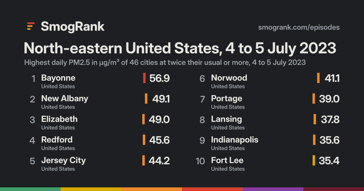
For 2 days, from 4 to 5 July 2023, 48 cities in the United States had PM2.5 at least twice their usual for the time of year. The worst reading was Bayonne, New Jersey, United States: 56.9 µg/m³ on 5 July, about 11× its usual 5.1. Ended 5 July.
Day by day
On the map: 94 fire detections, smoke traced by NOAA.
- Fires, seenHeat satellites detected that day (via NASA FIRMS); bigger and glowing means more detections in the area. Farm burning and other fires count too, not only wildfires.
- Smoke, tracedOutlined by NOAA analysts from satellite images, light to heavy. Traced for North America only; it can be high above the ground.
Under the cities, for each UTC day: fires satellites detected (via NASA FIRMS), smoke NOAA analysts traced and volcanic ash warnings for aircraft. They show what was in the air, not that it caused the readings.
Fires: NASA FIRMS (VIIRS). Traced smoke: NOAA Hazard Mapping System. Volcanic ash: aviation ash warnings (SIGMETs) via NOAA's Aviation Weather Center.
How it spread
Every city it reached
| City | Days | Highest | Above usual |
|---|---|---|---|
| BayonneNew Jersey, United States | 1 | 56.95 July | 11× |
| New AlbanyIndiana, United States | 1 | 49.15 July | 6.5× |
| Jersey CityNew Jersey, United States | 1 | 44.25 July | 5.0× |
| ElizabethNew Jersey, United States | 1 | 49.05 July | 4.9× |
| Fort LeeNew Jersey, United States | 1 | 35.45 July | 4.6× |
| RedfordMichigan, United States | 1 | 45.65 July | 4.4× |
| FlintMichigan, United States | 2 | 33.14 July | 4.4× |
| LansingMichigan, United States | 2 | 37.85 July | 4.3× |
| PortageIndiana, United States | 1 | 39.04 July | 4.2× |
| GahannaOhio, United States | 1 | 30.74 July | 4.0× |
| East ChicagoIndiana, United States | 1 | 31.84 July | 3.9× |
| JeffersonvilleIndiana, United States | 2 | 31.85 July | 3.7× |
| NorwoodOhio, United States | 1 | 41.15 July | 3.6× |
| LindenNew Jersey, United States | 1 | 33.85 July | 3.6× |
| Grand RapidsMichigan, United States | 2 | 34.85 July | 3.5× |
| WilkinsburgPennsylvania, United States | 1 | 32.35 July | 3.5× |
| New York CityNew York, United States | 1 | 30.65 July | 3.5× |
| Oak GroveKentucky, United States | 1 | 26.94 July | 3.5× |
| ClarksvilleTennessee, United States | 1 | 26.94 July | 3.5× |
| MasonOhio, United States | 1 | 28.95 July | 3.4× |
| SharonvilleOhio, United States | 1 | 28.95 July | 3.4× |
| IndianapolisIndiana, United States | 2 | 35.64 July | 3.3× |
| ChicagoIllinois, United States | 1 | 31.94 July | 3.3× |
| Des PlainesIllinois, United States | 1 | 28.74 July | 3.3× |
| AkronOhio, United States | 1 | 26.15 July | 3.3× |
| NorthbrookIllinois, United States | 1 | 28.95 July | 3.2× |
| HammondIndiana, United States | 1 | 30.44 July | 3.1× |
| DublinOhio, United States | 1 | 26.65 July | 3.1× |
| JeffersontownKentucky, United States | 1 | 26.04 July | 3.1× |
| Saint MatthewsKentucky, United States | 1 | 25.64 July | 3.1× |
| West MifflinPennsylvania, United States | 1 | 33.65 July | 3.0× |
| Terre HauteIndiana, United States | 1 | 31.34 July | 3.0× |
| GaryIndiana, United States | 1 | 29.04 July | 3.0× |
| WashingtonDistrict of Columbia, United States | 1 | 27.25 July | 3.0× |
| LouisvilleKentucky, United States | 1 | 27.25 July | 3.0× |
| MilwaukeeWisconsin, United States | 1 | 26.24 July | 3.0× |
| CantonOhio, United States | 1 | 30.15 July | 2.9× |
| ElkhartIndiana, United States | 1 | 28.64 July | 2.9× |
| CincinnatiOhio, United States | 1 | 31.35 July | 2.8× |
| SpringfieldOhio, United States | 1 | 29.15 July | 2.8× |
| South BendIndiana, United States | 1 | 26.34 July | 2.8× |
| Oak LawnIllinois, United States | 1 | 26.14 July | 2.8× |
| EvansvilleIndiana, United States | 1 | 25.34 July | 2.8× |
| East Saint LouisIllinois, United States | 1 | 26.14 July | 2.6× |
| WarrenOhio, United States | 1 | 26.05 July | 2.6× |
| MiddletownOhio, United States | 1 | 27.75 July | 2.4× |
| ClevelandOhio, United States | 1 | 25.65 July | 2.4× |
| Franklin ParkIllinois, United States | 1 | 25.34 July | 2.4× |
Daily means in µg/m³, over the days each city counted in this episode. Highest: its highest of those days. Usual: the city's median for the time of year of that day (its days within 21 days of the date, every year, leaving out the week either side of it). Above usual: its highest day against that, with a usual under 5 µg/m³ taken as 5.
Compared with other episodes in the United States
Number 29 of 151 episodes in the United States since our records began, by cities reached.
- Eastern United States and Canada, June and July 2023343
- Northern United States and Canada, July 2026328
- United States and Canada, July 2023322
- Eastern United States and Canada, May and June 2023317
- North-eastern United States and Canada, 29 July to 9 August 2025292
- Northern United States and Canada, May and June 2025247
- United States and Canada, June 2023195
- North-western United States and Canada, August 2023176
- North-western United States and Canada, 4 to 22 August 2026149
- Northern United States and Canada, July 2025140
- Northern United States and Canada, June 2025134
- North-western United States and Canada, July and August 2026117
- North-eastern United States, 4 to 5 July 202348
Bars: cities reached; colour: the level of the episode's highest daily reading. All 151.
Use this page
SmogRank, North-eastern United States, 4 to 5 July 2023: 48 cities with PM2.5 at twice their usual or more, 4 to 5 July 2023, smogrank.com/episodes/2023-07-04-north-eastern-united-states (accessed 19 November 2026).
You're welcome to reuse a single chart, image or figure with this citation and a link. Terms.
An episode is a run of days when many cities close to each other (four or more within 350 km on a day, 8 or more in all) each had a daily PM2.5 mean of at least 25 µg/m³ and at least 2 times their usual for that time of year. Found in our own measurements, not picked by hand. How we find episodes. Values are each city's daily mean of its own monitors; causes are the usual kinds for a pattern like this, not a confirmed source. Fire detections from NASA FIRMS; smoke maps from NOAA HMS. Dust: contains modified Copernicus Atmosphere Monitoring Service information 2023. Neither the European Commission nor ECMWF is responsible for any use that may be made of the Copernicus information or data it contains.