SmogRank / Episodes / Canada

North-western Canada and United States, July 2023

For 1 day, on 17 July 2023, 16 cities in Canada and the United States had PM2.5 at least twice their usual for the time of year. The worst reading was Rapid City, South Dakota, United States: 51.6 µg/m³ on 17 July, about 6.0× its usual 8.6. Ended 17 July.

Likely smoke from firesFires were detected within 300 km of the city on 6% of the counted city-days and smoke was mapped over the city on 94%. Satellites see crop, field and forest fires alike, so this doesn't say which burned.
Cities reached16in 2 countries
Days117 July 2023
Worst day17 July16 cities counted
Furthest above usual7.3×Gillette

Day by day

17 July 16 cities at twice their usual or more

On the map: 1,020 fire detections, smoke traced by NOAA.

14 Jul151617181920
Every measured city in the area, coloured by its PM2.5 that day; a dark ring marks a city at twice its usual or more. Bars: cities counted each day, coloured by their median level. Choose a day or press play; without JavaScript, the days link to that day's world ranking.
  • Fires, seenHeat satellites detected that day (via NASA FIRMS); bigger and glowing means more detections in the area. Farm burning and other fires count too, not only wildfires.
  • Smoke, tracedOutlined by NOAA analysts from satellite images, light to heavy. Traced for North America only; it can be high above the ground.

Under the cities, for each UTC day: fires satellites detected (via NASA FIRMS), smoke NOAA analysts traced and volcanic ash warnings for aircraft. They show what was in the air, not that it caused the readings.

Fires: NASA FIRMS (VIIRS). Traced smoke: NOAA Hazard Mapping System. Volcanic ash: aviation ash warnings (SIGMETs) via NOAA's Aviation Weather Center.

How it spread

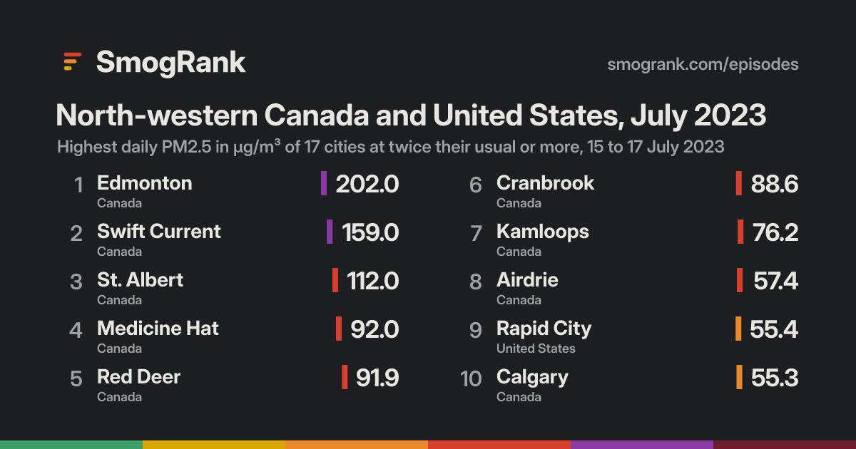
Rapid CityRapid City, 14 July: 26.5 µg/m³Rapid City, 15 July: 47.1 µg/m³Rapid City, 16 July: 55.4 µg/m³Rapid City, 17 July: 51.6 µg/m³, 6.0× its usual 8.6Rapid City, 18 July: 16.3 µg/m³Rapid City, 19 July: 13.6 µg/m³Rapid City, 20 July: 14.9 µg/m³EdmontonEdmonton, 14 July: no readingEdmonton, 15 July: 202.0 µg/m³Edmonton, 16 July: 111.0 µg/m³Edmonton, 17 July: 45.7 µg/m³, 3.8× its usual 12.1Edmonton, 18 July: 25.7 µg/m³Edmonton, 19 July: 22.8 µg/m³Edmonton, 20 July: 42.3 µg/m³BillingsBillings, 14 July: 29.0 µg/m³Billings, 15 July: 37.6 µg/m³Billings, 16 July: 31.2 µg/m³Billings, 17 July: 43.7 µg/m³, 6.1× its usual 7.2Billings, 18 July: no readingBillings, 19 July: 10.4 µg/m³Billings, 20 July: 13.4 µg/m³LockwoodLockwood, 14 July: no readingLockwood, 15 July: 37.6 µg/m³Lockwood, 16 July: 31.2 µg/m³Lockwood, 17 July: 43.7 µg/m³, 6.1× its usual 7.2Lockwood, 18 July: no readingLockwood, 19 July: 10.4 µg/m³Lockwood, 20 July: 13.4 µg/m³GilletteGillette, 14 July: 20.0 µg/m³Gillette, 15 July: 35.7 µg/m³Gillette, 16 July: 32.7 µg/m³Gillette, 17 July: 43.6 µg/m³, 7.3× its usual 6.0Gillette, 18 July: no readingGillette, 19 July: 8.7 µg/m³Gillette, 20 July: 11.6 µg/m³CalgaryCalgary, 14 July: no readingCalgary, 15 July: 49.9 µg/m³Calgary, 16 July: 47.1 µg/m³Calgary, 17 July: 42.2 µg/m³, 4.1× its usual 10.3Calgary, 18 July: 6.3 µg/m³Calgary, 19 July: 15.9 µg/m³Calgary, 20 July: 17.1 µg/m³Miles CityMiles City, 14 July: no readingMiles City, 15 July: 76.0 µg/m³Miles City, 16 July: 86.3 µg/m³Miles City, 17 July: 41.0 µg/m³, 5.3× its usual 7.7Miles City, 18 July: 13.2 µg/m³Miles City, 19 July: 11.6 µg/m³Miles City, 20 July: 10.6 µg/m³HavreHavre, 14 July: no readingHavre, 15 July: 60.4 µg/m³Havre, 16 July: 86.2 µg/m³Havre, 17 July: 39.6 µg/m³, 7.2× its usual 5.5Havre, 18 July: 6.2 µg/m³Havre, 19 July: 10.0 µg/m³Havre, 20 July: 12.8 µg/m³AirdrieAirdrie, 14 July: no readingAirdrie, 15 July: 40.8 µg/m³Airdrie, 16 July: 41.1 µg/m³Airdrie, 17 July: 36.4 µg/m³, 5.0× its usual 7.3Airdrie, 18 July: 8.3 µg/m³Airdrie, 19 July: 13.7 µg/m³Airdrie, 20 July: 13.7 µg/m³Drayton ValleyDrayton Valley, 14 July: no readingDrayton Valley, 15 July: 60.8 µg/m³Drayton Valley, 16 July: 45.2 µg/m³Drayton Valley, 17 July: 36.3 µg/m³, 4.7× its usual 7.8Drayton Valley, 18 July: 11.3 µg/m³Drayton Valley, 19 July: 16.7 µg/m³Drayton Valley, 20 July: 20.5 µg/m³LewistownLewistown, 14 July: no readingLewistown, 15 July: 43.2 µg/m³Lewistown, 16 July: 36.3 µg/m³Lewistown, 17 July: 35.4 µg/m³, 4.3× its usual 8.3Lewistown, 18 July: 5.7 µg/m³Lewistown, 19 July: 11.7 µg/m³Lewistown, 20 July: 12.9 µg/m³Grande PrairieGrande Prairie, 14 July: no readingGrande Prairie, 15 July: 94.9 µg/m³Grande Prairie, 16 July: 154.0 µg/m³Grande Prairie, 17 July: 34.7 µg/m³, 5.3× its usual 6.6Grande Prairie, 18 July: 8.9 µg/m³Grande Prairie, 19 July: 21.6 µg/m³Grande Prairie, 20 July: 67.0 µg/m³Fort SaskatchewanFort Saskatchewan, 14 July: no readingFort Saskatchewan, 15 July: 180.0 µg/m³Fort Saskatchewan, 16 July: 102.0 µg/m³Fort Saskatchewan, 17 July: 30.7 µg/m³, 3.0× its usual 10.3Fort Saskatchewan, 18 July: 17.8 µg/m³Fort Saskatchewan, 19 July: 14.5 µg/m³Fort Saskatchewan, 20 July: 30.2 µg/m³Medicine HatMedicine Hat, 14 July: no readingMedicine Hat, 15 July: 70.7 µg/m³Medicine Hat, 16 July: 92.0 µg/m³Medicine Hat, 17 July: 30.4 µg/m³, 4.0× its usual 7.6Medicine Hat, 18 July: 3.5 µg/m³Medicine Hat, 19 July: 9.8 µg/m³Medicine Hat, 20 July: 12.1 µg/m³Red DeerRed Deer, 14 July: no readingRed Deer, 15 July: 91.9 µg/m³Red Deer, 16 July: 57.7 µg/m³Red Deer, 17 July: 29.3 µg/m³, 3.1× its usual 9.5Red Deer, 18 July: 10.8 µg/m³Red Deer, 19 July: 16.8 µg/m³Red Deer, 20 July: 17.3 µg/m³Fort St. JohnFort St. John, 14 July: no readingFort St. John, 15 July: 82.2 µg/m³Fort St. John, 16 July: 90.8 µg/m³Fort St. John, 17 July: 26.3 µg/m³, 4.3× its usual 6.1Fort St. John, 18 July: 8.8 µg/m³Fort St. John, 19 July: 38.6 µg/m³Fort St. John, 20 July: 53.4 µg/m³14 Jul151617181920
Every counted city, in the order the episode reached them, 3 days before to 3 after. Each square is a day, coloured by that day's PM2.5; outlined: at twice the city's usual or more.
Good0–50
Moderate51–100
Unhealthy for sensitive groups101–150
Unhealthy151–200
Very unhealthy201–300
Hazardous301+

Every city it reached

CityDaysHighestUsualAbove usual
GilletteWyoming, United States1 43.617 July6.07.3×
HavreMontana, United States1 39.617 July5.57.2×
BillingsMontana, United States1 43.717 July7.26.1×
LockwoodMontana, United States1 43.717 July7.26.1×
Rapid CitySouth Dakota, United States1 51.617 July8.66.0×
Miles CityMontana, United States1 41.017 July7.75.3×
Grande PrairieAlberta, Canada1 34.717 July6.65.3×
AirdrieAlberta, Canada1 36.417 July7.35.0×
Drayton ValleyAlberta, Canada1 36.317 July7.84.7×
LewistownMontana, United States1 35.417 July8.34.3×
Fort St. JohnBritish Columbia, Canada1 26.317 July6.14.3×
CalgaryAlberta, Canada1 42.217 July10.34.1×
Medicine HatAlberta, Canada1 30.417 July7.64.0×
EdmontonAlberta, Canada1 45.717 July12.13.8×
Red DeerAlberta, Canada1 29.317 July9.53.1×
Fort SaskatchewanAlberta, Canada1 30.717 July10.33.0×

Daily means in µg/m³, over the days each city counted in this episode. Highest: its highest of those days. Usual: the city's median for the time of year of that day (its days within 21 days of the date, every year, leaving out the week either side of it). Above usual: its highest day against that, with a usual under 5 µg/m³ taken as 5.

Compared with other episodes in Canada and the United States

Number 93 of 173 episodes in Canada and the United States since our records began, by cities reached.

Bars: cities reached; colour: the level of the episode's highest daily reading. All 173.

Use this page

SmogRank, North-western Canada and United States, July 2023: 16 cities with PM2.5 at twice their usual or more, 17 July 2023, smogrank.com/episodes/2023-07-north-western-canada-and-united-states (accessed 17 November 2026).

Download top 10 (PNG)

You're welcome to reuse a single chart, image or figure with this citation and a link. Terms.

An episode is a run of days when many cities close to each other (four or more within 350 km on a day, 8 or more in all) each had a daily PM2.5 mean of at least 25 µg/m³ and at least 2 times their usual for that time of year. Found in our own measurements, not picked by hand. How we find episodes. Values are each city's daily mean of its own monitors; causes are the usual kinds for a pattern like this, not a confirmed source. Fire detections from NASA FIRMS; smoke maps from NOAA HMS.