SmogRank / Episodes / United States
North-eastern United States and Canada, September and October 2023
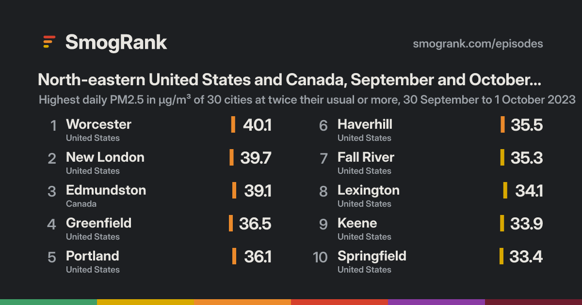
For 2 days, from 30 September to 1 October 2023, 34 cities in the United States and Canada had PM2.5 at least twice their usual for the time of year. The worst reading was Worcester, Massachusetts, United States: 40.1 µg/m³ on 1 October, about 8.0× its usual 4.1. Ended 1 October.
Likely smoke from fires Smoke was mapped over the city on 69% of the counted city-days NOAA's smoke maps cover. Satellites see crop, field and forest fires alike, so this doesn't say which burned.
Cities reached 34 in 2 countries
Days 2 30 September to 1 October 2023
Worst day 30 September 20 cities counted
Furthest above usual 8.0× Worcester
Day by day
Play 30 September 20 cities at twice their usual or more
Hartford Lewiston Derry Londonderry Burlington Augusta Saint-Jean-sur-Richelieu Bécancour Montréal Québec Dorval Pittsfield Bangor Albany New Haven Danbury Bridgeport Newburgh Utica White Plains Mount Ivy New City Presque Isle Ottawa Paterson Syracuse Kingston Scranton Fredericton Saint John Rivière-des-Prairies–Pointe-aux-Trembles L'Ancienne-Lorette North Adams Brossard Cornwall Drummondville Ware Waterbury Lynn Rutland Laconia West Greenwich Coventry Sherbrooke Portsmouth Lowell North Chicopee Providence Quincy Boston Bennington Hartford Granby Brockton Springfield Keene Lexington Fall River Haverhill Portland Greenfield Edmundston New London Worcester On the map: 9 fire detections, smoke traced by NOAA.
27 Sep 28 29 30 1 Oct 2 3 4 Every measured city in the area, coloured by its PM2.5 that day; a dark ring marks a city at twice its usual or more. Bars: cities counted each day, coloured by their median level. Choose a day or press play; without JavaScript, the days link to that day's world ranking. Fires, seen Heat satellites detected that day (via NASA FIRMS); bigger and glowing means more detections in the area. Farm burning and other fires count too, not only wildfires.Smoke, traced Outlined by NOAA analysts from satellite images, light to heavy. Traced for North America only; it can be high above the ground.Under the cities, for each UTC day: fires satellites detected (via NASA FIRMS), smoke NOAA analysts traced and volcanic ash warnings for aircraft. They show what was in the air, not that it caused the readings.
Fires: NASA FIRMS (VIIRS). Traced smoke: NOAA Hazard Mapping System. Volcanic ash: aviation ash warnings (SIGMETs) via NOAA's Aviation Weather Center.
How it spread
Edmundston Edmundston, 27 September: 9.3 µg/m³ Edmundston, 28 September: 11.0 µg/m³ Edmundston, 29 September: 13.1 µg/m³ Edmundston, 30 September: 39.1 µg/m³, 7.8× its usual 4.5 Edmundston, 1 October: 26.4 µg/m³ Edmundston, 2 October: 8.7 µg/m³ Edmundston, 3 October: 9.6 µg/m³ Edmundston, 4 October: 6.1 µg/m³ Greenfield Greenfield, 27 September: 5.9 µg/m³ Greenfield, 28 September: 9.1 µg/m³ Greenfield, 29 September: 13.5 µg/m³ Greenfield, 30 September: 36.5 µg/m³, 7.3× its usual 4.2 Greenfield, 1 October: 13.5 µg/m³ Greenfield, 2 October: 9.0 µg/m³ Greenfield, 3 October: 8.8 µg/m³ Greenfield, 4 October: 8.8 µg/m³ Keene Keene, 27 September: 5.9 µg/m³ Keene, 28 September: 11.4 µg/m³ Keene, 29 September: 17.9 µg/m³ Keene, 30 September: 33.9 µg/m³, 6.8× its usual 4.4 Keene, 1 October: 16.2 µg/m³ Keene, 2 October: 8.6 µg/m³ Keene, 3 October: 8.2 µg/m³ Keene, 4 October: 9.3 µg/m³ Springfield Springfield, 27 September: 7.2 µg/m³ Springfield, 28 September: 10.9 µg/m³ Springfield, 29 September: 12.1 µg/m³ Springfield, 30 September: 33.4 µg/m³, 6.7× its usual 5.0 Springfield, 1 October: 18.9 µg/m³ Springfield, 2 October: 9.8 µg/m³ Springfield, 3 October: 10.0 µg/m³ Springfield, 4 October: 11.1 µg/m³ Granby Granby, 27 September: 12.6 µg/m³ Granby, 28 September: 17.5 µg/m³ Granby, 29 September: 26.2 µg/m³ Granby, 30 September: 33.0 µg/m³, 6.6× its usual 4.6 Granby, 1 October: 22.2 µg/m³ Granby, 2 October: 11.1 µg/m³ Granby, 3 October: 9.9 µg/m³ Granby, 4 October: 11.4 µg/m³ Hartford Hartford, 27 September: 7.2 µg/m³ Hartford, 28 September: 12.7 µg/m³ Hartford, 29 September: 8.4 µg/m³ Hartford, 30 September: 32.9 µg/m³, 6.6× its usual 4.8 Hartford, 1 October: 24.1 µg/m³ Hartford, 2 October: 11.8 µg/m³ Hartford, 3 October: 10.7 µg/m³ Hartford, 4 October: 12.5 µg/m³ Bennington Bennington, 27 September: 4.6 µg/m³ Bennington, 28 September: 11.1 µg/m³ Bennington, 29 September: 13.9 µg/m³ Bennington, 30 September: 32.5 µg/m³, 6.5× its usual 3.4 Bennington, 1 October: 8.4 µg/m³ Bennington, 2 October: 5.6 µg/m³ Bennington, 3 October: 6.9 µg/m³ Bennington, 4 October: 8.1 µg/m³ North Chicopee North Chicopee, 27 September: 5.3 µg/m³ North Chicopee, 28 September: 8.7 µg/m³ North Chicopee, 29 September: 10.8 µg/m³ North Chicopee, 30 September: 31.4 µg/m³, 6.3× its usual 3.8 North Chicopee, 1 October: 16.2 µg/m³ North Chicopee, 2 October: 8.0 µg/m³ North Chicopee, 3 October: 7.8 µg/m³ North Chicopee, 4 October: 9.0 µg/m³ Sherbrooke Sherbrooke, 27 September: 11.8 µg/m³ Sherbrooke, 28 September: 15.5 µg/m³ Sherbrooke, 29 September: 23.5 µg/m³ Sherbrooke, 30 September: 29.9 µg/m³, 6.0× its usual 3.9 Sherbrooke, 1 October: 20.7 µg/m³ Sherbrooke, 2 October: 9.5 µg/m³ Sherbrooke, 3 October: 9.4 µg/m³ Sherbrooke, 4 October: 10.0 µg/m³ Laconia Laconia, 27 September: 5.2 µg/m³ Laconia, 28 September: 11.1 µg/m³ Laconia, 29 September: 14.7 µg/m³ Laconia, 30 September: 29.7 µg/m³, 5.9× its usual 3.0 Laconia, 1 October: 15.6 µg/m³ Laconia, 2 October: 6.5 µg/m³ Laconia, 3 October: 6.7 µg/m³ Laconia, 4 October: 9.2 µg/m³ Rutland Rutland, 27 September: 7.6 µg/m³ Rutland, 28 September: 13.2 µg/m³ Rutland, 29 September: 18.7 µg/m³ Rutland, 30 September: 29.7 µg/m³, 5.9× its usual 4.6 Rutland, 1 October: 11.2 µg/m³ Rutland, 2 October: 8.0 µg/m³ Rutland, 3 October: 9.6 µg/m³ Rutland, 4 October: 10.8 µg/m³ Waterbury Waterbury, 27 September: 7.3 µg/m³ Waterbury, 28 September: 12.5 µg/m³ Waterbury, 29 September: 5.6 µg/m³ Waterbury, 30 September: 28.6 µg/m³, 5.7× its usual 4.7 Waterbury, 1 October: 16.8 µg/m³ Waterbury, 2 October: 10.6 µg/m³ Waterbury, 3 October: 9.6 µg/m³ Waterbury, 4 October: 11.0 µg/m³ Ware Ware, 27 September: 5.0 µg/m³ Ware, 28 September: 8.0 µg/m³ Ware, 29 September: 10.5 µg/m³ Ware, 30 September: 28.1 µg/m³, 5.6× its usual 3.5 Ware, 1 October: 19.7 µg/m³ Ware, 2 October: 6.9 µg/m³ Ware, 3 October: 7.6 µg/m³ Ware, 4 October: 8.3 µg/m³ Drummondville Drummondville, 27 September: 10.8 µg/m³ Drummondville, 28 September: 16.8 µg/m³ Drummondville, 29 September: 22.6 µg/m³ Drummondville, 30 September: 28.1 µg/m³, 5.6× its usual 4.2 Drummondville, 1 October: 17.6 µg/m³ Drummondville, 2 October: 9.1 µg/m³ Drummondville, 3 October: 10.5 µg/m³ Drummondville, 4 October: 12.0 µg/m³ Cornwall Cornwall, 27 September: 12.5 µg/m³ Cornwall, 28 September: 17.1 µg/m³ Cornwall, 29 September: 21.3 µg/m³ Cornwall, 30 September: 27.6 µg/m³, 5.4× its usual 5.1 Cornwall, 1 October: 15.2 µg/m³ Cornwall, 2 October: 11.2 µg/m³ Cornwall, 3 October: 10.6 µg/m³ Cornwall, 4 October: 11.5 µg/m³ Brossard Brossard, 27 September: 10.9 µg/m³ Brossard, 28 September: 17.1 µg/m³ Brossard, 29 September: 21.8 µg/m³ Brossard, 30 September: 27.0 µg/m³, 5.4× its usual 4.8 Brossard, 1 October: 19.8 µg/m³ Brossard, 2 October: 10.4 µg/m³ Brossard, 3 October: 10.2 µg/m³ Brossard, 4 October: 11.0 µg/m³ North Adams North Adams, 27 September: 5.8 µg/m³ North Adams, 28 September: 14.6 µg/m³ North Adams, 29 September: 13.8 µg/m³ North Adams, 30 September: 26.3 µg/m³, 5.3× its usual 4.5 North Adams, 1 October: 13.1 µg/m³ North Adams, 2 October: 6.8 µg/m³ North Adams, 3 October: 8.6 µg/m³ North Adams, 4 October: 8.5 µg/m³ L'Ancienne-Lorette L'Ancienne-Lorette, 27 September: 13.7 µg/m³ L'Ancienne-Lorette, 28 September: 17.2 µg/m³ L'Ancienne-Lorette, 29 September: 22.4 µg/m³ L'Ancienne-Lorette, 30 September: 26.2 µg/m³, 5.2× its usual 4.8 L'Ancienne-Lorette, 1 October: 19.0 µg/m³ L'Ancienne-Lorette, 2 October: 9.5 µg/m³ L'Ancienne-Lorette, 3 October: 13.7 µg/m³ L'Ancienne-Lorette, 4 October: 12.2 µg/m³ Lexington Lexington, 27 September: 6.0 µg/m³ Lexington, 28 September: 10.4 µg/m³ Lexington, 29 September: 19.5 µg/m³ Lexington, 30 September: 25.8 µg/m³, 5.2× its usual 3.7 Lexington, 1 October: 34.1 µg/m³, 6.8× its usual 3.7 Lexington, 2 October: 12.8 µg/m³ Lexington, 3 October: 10.9 µg/m³ Lexington, 4 October: 17.4 µg/m³ Rivière-des-Prairie… Rivière-des-Prairies–Pointe-aux-Trembles, 27 September: 10.4 µg/m³ Rivière-des-Prairies–Pointe-aux-Trembles, 28 September: 18.5 µg/m³ Rivière-des-Prairies–Pointe-aux-Trembles, 29 September: 23.8 µg/m³ Rivière-des-Prairies–Pointe-aux-Trembles, 30 September: 25.7 µg/m³, 5.1× its usual 5.0 Rivière-des-Prairies–Pointe-aux-Trembles, 1 October: 18.1 µg/m³ Rivière-des-Prairies–Pointe-aux-Trembles, 2 October: 10.4 µg/m³ Rivière-des-Prairies–Pointe-aux-Trembles, 3 October: 11.9 µg/m³ Rivière-des-Prairies–Pointe-aux-Trembles, 4 October: 12.9 µg/m³ Worcester Worcester, 27 September: 6.7 µg/m³ Worcester, 28 September: 9.4 µg/m³ Worcester, 29 September: 11.8 µg/m³ Worcester, 30 September: no reading Worcester, 1 October: 40.1 µg/m³, 8.0× its usual 4.1 Worcester, 2 October: 10.7 µg/m³ Worcester, 3 October: 9.3 µg/m³ Worcester, 4 October: 12.0 µg/m³ New London New London, 27 September: 6.4 µg/m³ New London, 28 September: 10.9 µg/m³ New London, 29 September: 7.8 µg/m³ New London, 30 September: 24.0 µg/m³ New London, 1 October: 39.7 µg/m³, 7.9× its usual 4.0 New London, 2 October: 18.0 µg/m³ New London, 3 October: 9.3 µg/m³ New London, 4 October: 12.6 µg/m³ Portland Portland, 27 September: 7.5 µg/m³ Portland, 28 September: 9.3 µg/m³ Portland, 29 September: 11.7 µg/m³ Portland, 30 September: 17.2 µg/m³ Portland, 1 October: 36.1 µg/m³, 7.2× its usual 4.2 Portland, 2 October: 9.2 µg/m³ Portland, 3 October: 11.2 µg/m³ Portland, 4 October: 12.8 µg/m³ Haverhill Haverhill, 27 September: 5.6 µg/m³ Haverhill, 28 September: 7.5 µg/m³ Haverhill, 29 September: 10.8 µg/m³ Haverhill, 30 September: 15.4 µg/m³ Haverhill, 1 October: 35.5 µg/m³, 7.1× its usual 4.4 Haverhill, 2 October: 10.7 µg/m³ Haverhill, 3 October: 7.9 µg/m³ Haverhill, 4 October: 10.2 µg/m³ Fall River Fall River, 27 September: 6.4 µg/m³ Fall River, 28 September: 11.0 µg/m³ Fall River, 29 September: 12.3 µg/m³ Fall River, 30 September: 23.0 µg/m³ Fall River, 1 October: 35.3 µg/m³, 7.1× its usual 4.1 Fall River, 2 October: 15.5 µg/m³ Fall River, 3 October: 9.9 µg/m³ Fall River, 4 October: 12.3 µg/m³ Brockton Brockton, 27 September: 6.6 µg/m³ Brockton, 28 September: 9.0 µg/m³ Brockton, 29 September: 13.0 µg/m³ Brockton, 30 September: 23.9 µg/m³ Brockton, 1 October: 33.4 µg/m³, 6.7× its usual 4.6 Brockton, 2 October: 14.3 µg/m³ Brockton, 3 October: 9.1 µg/m³ Brockton, 4 October: 11.0 µg/m³ Boston Boston, 27 September: 6.5 µg/m³ Boston, 28 September: 7.9 µg/m³ Boston, 29 September: 14.1 µg/m³ Boston, 30 September: 18.5 µg/m³ Boston, 1 October: 31.8 µg/m³, 6.4× its usual 4.6 Boston, 2 October: 13.5 µg/m³ Boston, 3 October: 9.3 µg/m³ Boston, 4 October: 12.7 µg/m³ Quincy Quincy, 27 September: 6.4 µg/m³ Quincy, 28 September: 7.8 µg/m³ Quincy, 29 September: 13.5 µg/m³ Quincy, 30 September: 21.6 µg/m³ Quincy, 1 October: 31.7 µg/m³, 6.3× its usual 4.1 Quincy, 2 October: 13.4 µg/m³ Quincy, 3 October: 8.3 µg/m³ Quincy, 4 October: 11.3 µg/m³ Providence Providence, 27 September: 8.1 µg/m³ Providence, 28 September: 11.0 µg/m³ Providence, 29 September: 12.1 µg/m³ Providence, 30 September: 21.5 µg/m³ Providence, 1 October: 31.5 µg/m³, 6.3× its usual 5.0 Providence, 2 October: 16.1 µg/m³ Providence, 3 October: 11.1 µg/m³ Providence, 4 October: 13.5 µg/m³ Lowell Lowell, 27 September: 6.0 µg/m³ Lowell, 28 September: 8.4 µg/m³ Lowell, 29 September: 13.1 µg/m³ Lowell, 30 September: 19.5 µg/m³ Lowell, 1 October: 31.3 µg/m³, 6.3× its usual 4.4 Lowell, 2 October: 11.0 µg/m³ Lowell, 3 October: 7.8 µg/m³ Lowell, 4 October: 11.3 µg/m³ Portsmouth Portsmouth, 27 September: 5.9 µg/m³ Portsmouth, 28 September: 8.5 µg/m³ Portsmouth, 29 September: 11.7 µg/m³ Portsmouth, 30 September: 12.1 µg/m³ Portsmouth, 1 October: 30.8 µg/m³, 6.2× its usual 4.1 Portsmouth, 2 October: 9.3 µg/m³ Portsmouth, 3 October: 8.0 µg/m³ Portsmouth, 4 October: 10.6 µg/m³ Coventry Coventry, 27 September: 9.6 µg/m³ Coventry, 28 September: 13.0 µg/m³ Coventry, 29 September: 10.9 µg/m³ Coventry, 30 September: 21.5 µg/m³ Coventry, 1 October: 29.8 µg/m³, 6.0× its usual 3.6 Coventry, 2 October: 13.3 µg/m³ Coventry, 3 October: 8.2 µg/m³ Coventry, 4 October: 9.8 µg/m³ West Greenwich West Greenwich, 27 September: 9.6 µg/m³ West Greenwich, 28 September: 13.0 µg/m³ West Greenwich, 29 September: 10.9 µg/m³ West Greenwich, 30 September: 21.5 µg/m³ West Greenwich, 1 October: 29.8 µg/m³, 6.0× its usual 3.5 West Greenwich, 2 October: 13.3 µg/m³ West Greenwich, 3 October: 8.2 µg/m³ West Greenwich, 4 October: 9.8 µg/m³ Lynn Lynn, 27 September: 5.7 µg/m³ Lynn, 28 September: 7.3 µg/m³ Lynn, 29 September: 10.8 µg/m³ Lynn, 30 September: 14.2 µg/m³ Lynn, 1 October: 29.0 µg/m³, 5.8× its usual 4.0 Lynn, 2 October: 11.3 µg/m³ Lynn, 3 October: 7.7 µg/m³ Lynn, 4 October: 9.9 µg/m³ 27 Sep 28 29 30 1 Oct 2 3 4 Every counted city, in the order the episode reached them, 3 days before to 3 after. Each square is a day, coloured by that day's PM2.5; outlined: at twice the city's usual or more. Good 0–50
Moderate 51–100
Unhealthy for sensitive groups 101–150
Unhealthy 151–200
Very unhealthy 201–300
Hazardous 301+
Every city it reached
City Days Highest Usual Above usual
Worcester Massachusetts, United States 1 1 October 4.1 8.0× New London Connecticut, United States 1 1 October 4.0 7.9× Edmundston New Brunswick, Canada 1 30 September 4.5 7.8× Greenfield Massachusetts, United States 1 30 September 4.2 7.3× Portland Maine, United States 1 1 October 4.2 7.2× Haverhill Massachusetts, United States 1 1 October 4.4 7.1× Fall River Massachusetts, United States 1 1 October 4.1 7.1× Lexington Massachusetts, United States 2 1 October 3.7 6.8× Keene New Hampshire, United States 1 30 September 4.4 6.8× Springfield Massachusetts, United States 1 30 September 5.0 6.7× Brockton Massachusetts, United States 1 1 October 4.6 6.7× Granby Quebec, Canada 1 30 September 4.6 6.6× Hartford Connecticut, United States 1 30 September 4.8 6.6× Bennington Vermont, United States 1 30 September 3.4 6.5× Boston Massachusetts, United States 1 1 October 4.6 6.4× Quincy Massachusetts, United States 1 1 October 4.1 6.3× Providence Rhode Island, United States 1 1 October 5.0 6.3× North Chicopee Massachusetts, United States 1 30 September 3.8 6.3× Lowell Massachusetts, United States 1 1 October 4.4 6.3× Portsmouth New Hampshire, United States 1 1 October 4.1 6.2× Sherbrooke Quebec, Canada 1 30 September 3.9 6.0× Coventry Rhode Island, United States 1 1 October 3.6 6.0× West Greenwich Rhode Island, United States 1 1 October 3.5 6.0× Laconia New Hampshire, United States 1 30 September 3.0 5.9× Rutland Vermont, United States 1 30 September 4.6 5.9× Lynn Massachusetts, United States 1 1 October 4.0 5.8× Waterbury Connecticut, United States 1 30 September 4.7 5.7× Ware Massachusetts, United States 1 30 September 3.5 5.6× Drummondville Quebec, Canada 1 30 September 4.2 5.6× Cornwall Ontario, Canada 1 30 September 5.1 5.4× Brossard Quebec, Canada 1 30 September 4.8 5.4× North Adams Massachusetts, United States 1 30 September 4.5 5.3× L'Ancienne-Lorette Quebec, Canada 1 30 September 4.8 5.2× Rivière-des-Prairies–Pointe-aux-Trembles Quebec, Canada 1 30 September 5.0 5.1×
Daily means in µg/m³, over the days each city counted in this episode. Highest: its highest of those days. Usual: the city's median for the time of year of that day (its days within 21 days of the date, every year, leaving out the week either side of it). Above usual: its highest day against that, with a usual under 5 µg/m³ taken as 5.
Compared with other episodes in the United States and Canada
Number 40 of 173 episodes in the United States and Canada since our records began, by cities reached.
Eastern United States and Canada, June and July 2023 343 Northern United States and Canada, July 2026 328 United States and Canada, July 2023 322 Eastern United States and Canada, May and June 2023 317 North-eastern United States and Canada, 29 July to 9 August 2025 292 Northern United States and Canada, May and June 2025 247 United States and Canada, June 2023 195 North-western United States and Canada, August 2023 176 North-western United States and Canada, 4 to 22 August 2026 149 Northern United States and Canada, July 2025 140 Northern United States and Canada, June 2025 134 North-western United States and Canada, July and August 2026 117 North-eastern United States and Canada, September and October 2023 34 Bars: cities reached; colour: the level of the episode's highest daily reading. All 173 .
Use this page SmogRank, North-eastern United States and Canada, September and October 2023: 34 cities with PM2.5 at twice their usual or more, 30 September to 1 October 2023, smogrank.com/episodes/2023-09-north-eastern-united-states-and-canada (accessed 17 November 2026).
Share Copy citation Download top 10 (PNG)
You're welcome to reuse a single chart, image or figure with this citation and a link. Terms .
An episode is a run of days when many cities close to each other (four or more within 350 km on a day, 8 or more in all) each had a daily PM2.5 mean of at least 25 µg/m³ and at least 2 times their usual for that time of year. Found in our own measurements, not picked by hand. How we find episodes . Values are each city's daily mean of its own monitors; causes are the usual kinds for a pattern like this, not a confirmed source. Fire detections from NASA FIRMS; smoke maps from NOAA HMS. Dust: contains modified Copernicus Atmosphere Monitoring Service information 2023. Neither the European Commission nor ECMWF is responsible for any use that may be made of the Copernicus information or data it contains.