SmogRank / Episodes / United States

Washington and Idaho, United States, October 2025

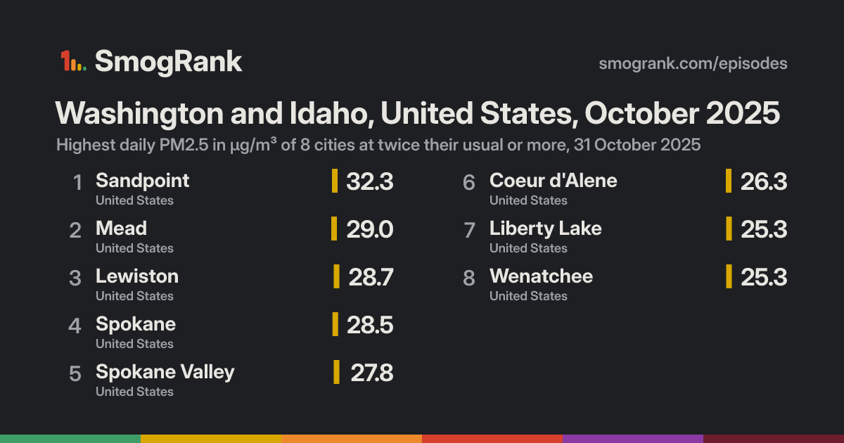
For 1 day, on 31 October 2025, 8 cities in the United States had PM2.5 at least twice their usual for the time of year. The worst reading was Sandpoint, Idaho, United States: 32.3 µg/m³ on 31 October, about 3.1× its usual 10.4. Ended 31 October.

Likely smoke from firesFires were detected within 300 km of the city on 100% of the counted city-days. Satellites see crop, field and forest fires alike, so this doesn't say which burned.
Cities reached8in 1 country
Days131 October 2025
Worst day31 October8 cities counted
Furthest above usual5.1×Mead

Day by day

31 October 8 cities at twice their usual or more
Moses LakeAirway HeightsEphrataWalla WallaTri-CitiesPullmanQuincyMoscowPendletonHermistonProsserSunnysideLa GrandeToppenishCastlegarEllensburgYakimaThe DallesNorth BendCranbrookHood RiverUnion Hill-Novelty HillHopeBellevueRentonKirklandBothellAuburnInglewood-Finn HillAgassizColumbia CityPicnic Point-North LynnwoodSeattleBurienWhite CenterShorelineChilliwackParklandTacomaMount VernonAbbotsfordBremertonMissionBellinghamOak HarborLyndenAnacortesColumbia FallsPort TownsendLaceyGreshamMissoulaSalmon CreekVancouverCentraliaRidgefieldLangleyChehalisNorth PortlandMilwaukiePortlandOregon CityLongviewSheltonCanbyPort CoquitlamTigardBeavertonCoquitlamStrawberry HillHillsboroBurnabyDeltaSilvertonWoodburnForest GroveNorth VancouverVictoriaRichmondPort AngelesVancouverWest VancouverLangfordSalemMcMinnvilleSquamishAberdeenDallasNorth CowichanDuncanGibsonsNanaimoHarewoodLethbridgeSandpointLewistonWenatcheeCoeur d'AleneSpokaneSpokane ValleyLiberty LakeMead
28 Oct2930311 Nov23
Every measured city in the area, coloured by its PM2.5 that day; a dark ring marks a city at twice its usual or more. Bars: cities counted each day, coloured by their median level. Choose a day or press play; without JavaScript, the days link to that day's world ranking.

How it spread

SandpointSandpoint, 28 October: 15.5 µg/m³Sandpoint, 29 October: 22.3 µg/m³Sandpoint, 30 October: 33.4 µg/m³Sandpoint, 31 October: 32.3 µg/m³, 3.1× its usual 10.4Sandpoint, 1 November: 22.6 µg/m³Sandpoint, 2 November: 13.2 µg/m³Sandpoint, 3 November: 17.7 µg/m³MeadMead, 28 October: no readingMead, 29 October: no readingMead, 30 October: no readingMead, 31 October: 29.0 µg/m³, 5.1× its usual 5.7Mead, 1 November: 13.9 µg/m³Mead, 2 November: 3.7 µg/m³Mead, 3 November: 9.5 µg/m³LewistonLewiston, 28 October: 5.1 µg/m³Lewiston, 29 October: 5.4 µg/m³Lewiston, 30 October: 14.6 µg/m³Lewiston, 31 October: 28.7 µg/m³, 3.3× its usual 8.6Lewiston, 1 November: 10.7 µg/m³Lewiston, 2 November: 2.9 µg/m³Lewiston, 3 November: 14.6 µg/m³SpokaneSpokane, 28 October: 8.5 µg/m³Spokane, 29 October: 8.1 µg/m³Spokane, 30 October: 15.0 µg/m³Spokane, 31 October: 28.5 µg/m³, 4.1× its usual 6.9Spokane, 1 November: 15.0 µg/m³Spokane, 2 November: 4.0 µg/m³Spokane, 3 November: 10.0 µg/m³Spokane ValleySpokane Valley, 28 October: 8.4 µg/m³Spokane Valley, 29 October: 7.9 µg/m³Spokane Valley, 30 October: 17.3 µg/m³Spokane Valley, 31 October: 27.8 µg/m³, 4.2× its usual 6.6Spokane Valley, 1 November: 15.0 µg/m³Spokane Valley, 2 November: 2.9 µg/m³Spokane Valley, 3 November: 10.8 µg/m³Coeur d'AleneCoeur d'Alene, 28 October: 8.6 µg/m³Coeur d'Alene, 29 October: 8.2 µg/m³Coeur d'Alene, 30 October: 20.6 µg/m³Coeur d'Alene, 31 October: 26.3 µg/m³, 3.6× its usual 7.3Coeur d'Alene, 1 November: 12.0 µg/m³Coeur d'Alene, 2 November: 5.0 µg/m³Coeur d'Alene, 3 November: 12.4 µg/m³Liberty LakeLiberty Lake, 28 October: 8.0 µg/m³Liberty Lake, 29 October: 6.3 µg/m³Liberty Lake, 30 October: 21.7 µg/m³Liberty Lake, 31 October: 25.3 µg/m³, 5.1× its usual 5.0Liberty Lake, 1 November: 14.6 µg/m³Liberty Lake, 2 November: 3.9 µg/m³Liberty Lake, 3 November: 10.6 µg/m³WenatcheeWenatchee, 28 October: 9.8 µg/m³Wenatchee, 29 October: 6.9 µg/m³Wenatchee, 30 October: 8.3 µg/m³Wenatchee, 31 October: 25.3 µg/m³, 3.5× its usual 7.3Wenatchee, 1 November: 27.2 µg/m³Wenatchee, 2 November: 4.6 µg/m³Wenatchee, 3 November: 7.4 µg/m³28 Oct2930311 Nov23
Every counted city, in the order the episode reached them, 3 days before to 3 after. Each square is a day, coloured by that day's PM2.5; outlined: at twice the city's usual or more.
Good0–50
Moderate51–100
Sensitive groups101–150
Unhealthy151–200
Very unhealthy201–300
Hazardous301+

Every city it reached

CityDaysHighestUsualAbove usual
MeadWashington, United States1 29.031 October5.75.1×
Liberty LakeWashington, United States1 25.331 October5.05.1×
Spokane ValleyWashington, United States1 27.831 October6.64.2×
SpokaneWashington, United States1 28.531 October6.94.1×
Coeur d'AleneIdaho, United States1 26.331 October7.33.6×
WenatcheeWashington, United States1 25.331 October7.33.5×
LewistonIdaho, United States1 28.731 October8.63.3×
SandpointIdaho, United States1 32.331 October10.43.1×

Daily means in µg/m³, over the days each city counted in this episode. Highest: its highest of those days. Usual: the city's median for the time of year of that day (its days within 21 days of the date, every year, leaving out the week around it). Above usual: its highest day against that, with a usual under 5 µg/m³ taken as 5.

Against other episodes in the United States

Number 142 of 151 episodes in the United States since our records began, by cities reached.

Bars: cities reached; colour: the level of the episode's highest daily reading. All 151.

Use this page

SmogRank, Washington and Idaho, United States, October 2025: 8 cities with PM2.5 at twice their usual or more, 31 October 2025, smogrank.com/episodes/2025-10-washington-and-idaho-united-states (accessed 5 October 2026).

Download top 10 (PNG)

You're welcome to reuse a single chart, image or figure with this citation and a link. Terms.

An episode is a run of days when many cities close to each other (four or more within 350 km on a day, 8 or more in all) each had a daily PM2.5 mean of at least 25 µg/m³ and at least 2 times their usual for that time of year. Found in our own measurements, not picked by hand. How we find episodes. Values are each city's daily mean of its own monitors; causes are the usual kinds for a pattern like this, not a confirmed source. Fire detections from NASA FIRMS; smoke maps from NOAA HMS.