SmogRank / Episodes / United States
North-eastern United States, June and July 2026
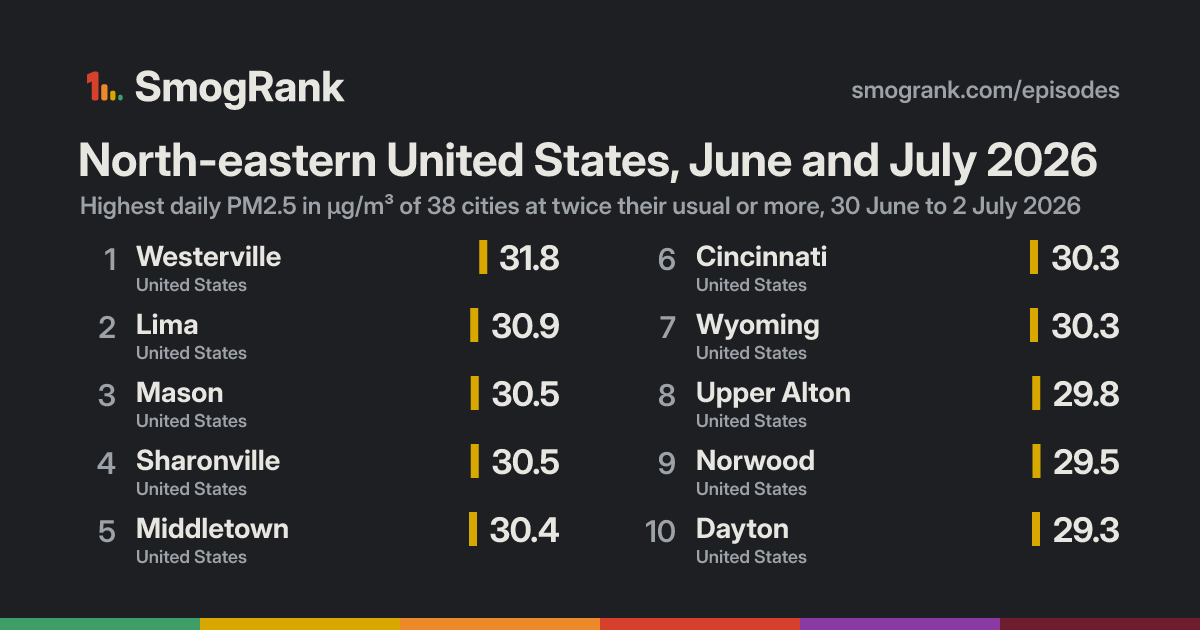
For 3 days, from 30 June to 2 July 2026, 38 cities in the United States had PM2.5 at least twice their usual for the time of year. The worst reading was Westerville, Ohio, United States: 31.8 µg/m³ on 1 July, about 3.1× its usual 10.3. Ended 2 July.
Likely smoke from fires Fires were detected within 300 km of the city on 70% of the counted city-days. Satellites see crop, field and forest fires alike, so this doesn't say which burned.
Cities reached 38 in 1 country
Days 3 30 June to 2 July 2026
Worst day 1 July 30 cities counted
Furthest above usual 4.0× Frostburg
Day by day
Play 1 July 30 cities at twice their usual or more
New Albany Gahanna Dublin Akron Warrensville Heights Shaker Heights Toledo Moundsville Painesville Steubenville Warren Weirton Ashland Weirton Heights Youngstown Windsor Lincoln Park Taylor Detroit Chatham Dearborn Eastpointe Ypsilanti Tecumseh Beaver Falls Royal Oak Hermitage New Brighton Southfield Charleston Ann Arbor New Baltimore Canonsburg Bridgeville Kennedy Township Fort Thomas Upper Saint Clair Highland Heights White Oak Pittsburgh Dent Jefferson Hills Port Huron Sarnia Wilkinsburg Monessen West Mifflin McKeesport St. Thomas Fort Wayne Natrona Heights Uniontown London Muncie Pikeville Greensburg Erie Beecher Lexington-Fayette Anderson Nicholasville McCordsville Brantford Johnstown Fishers Kitchener Warren Kalamazoo Columbus Kokomo Elkhart Indianapolis Jeffersontown Saint Matthews Hamilton Jeffersonville Waterdown Louisville New Albany South Bend Altoona Valley Station Harrisonburg Oakville Bloomington St. Catharines Elizabethtown Holland Buffalo Lafayette Michigan City State College Charlottesville Halfway Hagerstown Chambersburg Portage Jasper Gary Terre Haute East Chicago Hammond Ashburn Calumet City Dolton Carlisle Schlusser Blue Island Chicago Evergreen Park Oak Lawn Evanston Rockville Lincolnwood Bridgeview Skokie Springfield Elmwood Park Brookfield Niles Rochester Short Pump Harrisburg Park Ridge Rose Hill Franklin Park Evansville Washington Des Plaines Brandermill Scaggsville Joliet Oxon Hill-Glassmanor Zion Winthrop Harbor Richmond Champaign South Laurel Savoy Braidwood Naperville Warrenville Hunt Valley South Milwaukee Baltimore Aurora Elgin Cary Lebanon Greendale Essex Lancaster Brookfield Edgewood Waukesha New Holland Decatur Wyomissing Bloomington Reading Oconomowoc Cambridge Elkton Newark Glasgow Kennett Square Syracuse Bear Rockford Scranton Wilmington Allentown Claymont Dover Seaford Bethlehem Peoria Chester Norristown Springfield Paulsboro Philadelphia Sewell Abington Camden Madison Pennsauken Palmyra South Vineland Middleton Bensalem Utica Trenton Clinton East Saint Louis Mendham Baraboo Randolph St. Louis Jerseyville Pleasantville New Brunswick Lemay University City Smithville Moline Atlantic City Arnold Davenport Linden Elizabeth Toms River Paterson Bayonne Jersey City New York City Mount Ivy Fort Lee New City Newburgh Muscatine White Plains Albany Redford Grand Rapids Cleveland Wyoming Canton Columbus Oregon Owensboro Wheelersburg Portsmouth Flatwoods Norwood Middletown Jenison Hudsonville Lansing Milwaukee Northbrook Granite City Springfield Ewing Perrysburg Maumee Cincinnati Hershey Columbia City Dayton Lebanon Westerville Medina Lima York Upper Alton Cleveland Heights Wood River Sharonville Mason Frostburg 27 Jun 28 29 30 1 Jul 2 3 4 5 Every measured city in the area, coloured by its PM2.5 that day; a dark ring marks a city at twice its usual or more. Bars: cities counted each day, coloured by their median level. Choose a day or press play; without JavaScript, the days link to that day's world ranking.
How it spread
Upper Alton Upper Alton, 27 June: 11.5 µg/m³ Upper Alton, 28 June: 17.4 µg/m³ Upper Alton, 29 June: 18.1 µg/m³ Upper Alton, 30 June: 29.8 µg/m³, 3.3× its usual 8.9 Upper Alton, 1 July: 20.6 µg/m³ Upper Alton, 2 July: 14.5 µg/m³ Upper Alton, 3 July: 15.4 µg/m³ Upper Alton, 4 July: 19.2 µg/m³ Upper Alton, 5 July: 16.9 µg/m³ Wood River Wood River, 27 June: 10.0 µg/m³ Wood River, 28 June: 13.2 µg/m³ Wood River, 29 June: 16.2 µg/m³ Wood River, 30 June: 27.5 µg/m³, 3.5× its usual 7.8 Wood River, 1 July: 20.2 µg/m³ Wood River, 2 July: 13.5 µg/m³ Wood River, 3 July: 14.2 µg/m³ Wood River, 4 July: 15.6 µg/m³ Wood River, 5 July: 14.4 µg/m³ Granite City Granite City, 27 June: 8.8 µg/m³ Granite City, 28 June: 14.3 µg/m³ Granite City, 29 June: 17.1 µg/m³ Granite City, 30 June: 27.2 µg/m³, 2.9× its usual 9.5 Granite City, 1 July: 19.4 µg/m³ Granite City, 2 July: 13.8 µg/m³ Granite City, 3 July: 15.0 µg/m³ Granite City, 4 July: 18.6 µg/m³ Granite City, 5 July: 15.0 µg/m³ Owensboro Owensboro, 27 June: 9.1 µg/m³ Owensboro, 28 June: 11.9 µg/m³ Owensboro, 29 June: 14.4 µg/m³ Owensboro, 30 June: 25.0 µg/m³, 2.7× its usual 9.4 Owensboro, 1 July: 22.3 µg/m³ Owensboro, 2 July: 16.5 µg/m³ Owensboro, 3 July: 11.7 µg/m³ Owensboro, 4 July: 11.8 µg/m³ Owensboro, 5 July: 12.3 µg/m³ Westerville Westerville, 27 June: 6.9 µg/m³ Westerville, 28 June: 6.3 µg/m³ Westerville, 29 June: 10.9 µg/m³ Westerville, 30 June: 20.2 µg/m³ Westerville, 1 July: 31.8 µg/m³, 3.1× its usual 10.3 Westerville, 2 July: 25.1 µg/m³, 2.4× its usual 10.3 Westerville, 3 July: 19.2 µg/m³ Westerville, 4 July: 17.0 µg/m³ Westerville, 5 July: 20.1 µg/m³ Lima Lima, 27 June: 12.4 µg/m³ Lima, 28 June: 12.4 µg/m³ Lima, 29 June: 15.2 µg/m³ Lima, 30 June: 23.5 µg/m³ Lima, 1 July: 30.9 µg/m³, 3.2× its usual 9.7 Lima, 2 July: 20.6 µg/m³ Lima, 3 July: 17.0 µg/m³ Lima, 4 July: 13.4 µg/m³ Lima, 5 July: 13.8 µg/m³ Mason Mason, 27 June: 5.2 µg/m³ Mason, 28 June: 3.6 µg/m³ Mason, 29 June: 13.5 µg/m³ Mason, 30 June: 18.6 µg/m³ Mason, 1 July: 30.5 µg/m³, 3.6× its usual 8.4 Mason, 2 July: 21.0 µg/m³ Mason, 3 July: 16.0 µg/m³ Mason, 4 July: 8.7 µg/m³ Mason, 5 July: 7.1 µg/m³ Sharonville Sharonville, 27 June: 5.2 µg/m³ Sharonville, 28 June: 3.6 µg/m³ Sharonville, 29 June: 13.5 µg/m³ Sharonville, 30 June: 18.6 µg/m³ Sharonville, 1 July: 30.5 µg/m³, 3.6× its usual 8.4 Sharonville, 2 July: 21.0 µg/m³ Sharonville, 3 July: 16.0 µg/m³ Sharonville, 4 July: 8.7 µg/m³ Sharonville, 5 July: 7.1 µg/m³ Middletown Middletown, 27 June: 11.1 µg/m³ Middletown, 28 June: 7.6 µg/m³ Middletown, 29 June: 17.0 µg/m³ Middletown, 30 June: 22.9 µg/m³ Middletown, 1 July: 30.4 µg/m³, 2.7× its usual 11.3 Middletown, 2 July: 23.4 µg/m³ Middletown, 3 July: 21.9 µg/m³ Middletown, 4 July: 21.0 µg/m³ Middletown, 5 July: 11.8 µg/m³ Cincinnati Cincinnati, 27 June: 7.1 µg/m³ Cincinnati, 28 June: 6.8 µg/m³ Cincinnati, 29 June: 15.0 µg/m³ Cincinnati, 30 June: 20.9 µg/m³ Cincinnati, 1 July: 30.3 µg/m³, 2.9× its usual 10.6 Cincinnati, 2 July: 20.9 µg/m³ Cincinnati, 3 July: 16.9 µg/m³ Cincinnati, 4 July: 14.2 µg/m³ Cincinnati, 5 July: 10.6 µg/m³ Wyoming Wyoming, 27 June: 11.2 µg/m³ Wyoming, 28 June: 11.4 µg/m³ Wyoming, 29 June: 13.7 µg/m³ Wyoming, 30 June: 21.7 µg/m³ Wyoming, 1 July: 30.3 µg/m³, 2.5× its usual 12.0 Wyoming, 2 July: 15.6 µg/m³ Wyoming, 3 July: 12.3 µg/m³ Wyoming, 4 July: no reading Wyoming, 5 July: no reading Norwood Norwood, 27 June: 7.1 µg/m³ Norwood, 28 June: 7.0 µg/m³ Norwood, 29 June: 16.6 µg/m³ Norwood, 30 June: 21.7 µg/m³ Norwood, 1 July: 29.5 µg/m³, 2.7× its usual 11.0 Norwood, 2 July: 22.4 µg/m³ Norwood, 3 July: 19.9 µg/m³ Norwood, 4 July: 13.7 µg/m³ Norwood, 5 July: 12.8 µg/m³ Dayton Dayton, 27 June: 7.8 µg/m³ Dayton, 28 June: 4.8 µg/m³ Dayton, 29 June: 13.9 µg/m³ Dayton, 30 June: 20.6 µg/m³ Dayton, 1 July: 29.3 µg/m³, 3.0× its usual 9.8 Dayton, 2 July: 20.5 µg/m³ Dayton, 3 July: 14.7 µg/m³ Dayton, 4 July: 16.0 µg/m³ Dayton, 5 July: 11.2 µg/m³ Maumee Maumee, 27 June: 7.9 µg/m³ Maumee, 28 June: 10.4 µg/m³ Maumee, 29 June: 11.5 µg/m³ Maumee, 30 June: 21.3 µg/m³ Maumee, 1 July: 28.6 µg/m³, 2.9× its usual 9.9 Maumee, 2 July: 20.8 µg/m³ Maumee, 3 July: 14.2 µg/m³ Maumee, 4 July: 12.7 µg/m³ Maumee, 5 July: 14.6 µg/m³ Perrysburg Perrysburg, 27 June: 7.9 µg/m³ Perrysburg, 28 June: 10.4 µg/m³ Perrysburg, 29 June: 11.5 µg/m³ Perrysburg, 30 June: 21.3 µg/m³ Perrysburg, 1 July: 28.6 µg/m³, 2.9× its usual 9.9 Perrysburg, 2 July: 20.8 µg/m³ Perrysburg, 3 July: 14.2 µg/m³ Perrysburg, 4 July: 12.7 µg/m³ Perrysburg, 5 July: 14.6 µg/m³ Springfield Springfield, 27 June: 7.3 µg/m³ Springfield, 28 June: 5.7 µg/m³ Springfield, 29 June: 13.0 µg/m³ Springfield, 30 June: 18.6 µg/m³ Springfield, 1 July: 28.0 µg/m³, 2.9× its usual 9.8 Springfield, 2 July: 20.2 µg/m³ Springfield, 3 July: 15.1 µg/m³ Springfield, 4 July: 20.0 µg/m³ Springfield, 5 July: 18.8 µg/m³ Oregon Oregon, 27 June: 5.6 µg/m³ Oregon, 28 June: 7.1 µg/m³ Oregon, 29 June: 9.4 µg/m³ Oregon, 30 June: 21.1 µg/m³ Oregon, 1 July: 27.6 µg/m³, 2.6× its usual 10.6 Oregon, 2 July: 21.6 µg/m³ Oregon, 3 July: 14.6 µg/m³ Oregon, 4 July: 9.6 µg/m³ Oregon, 5 July: 7.2 µg/m³ Columbia City Columbia City, 27 June: 8.2 µg/m³ Columbia City, 28 June: 8.3 µg/m³ Columbia City, 29 June: 11.7 µg/m³ Columbia City, 30 June: 23.1 µg/m³ Columbia City, 1 July: 27.2 µg/m³, 3.0× its usual 9.2 Columbia City, 2 July: 16.5 µg/m³ Columbia City, 3 July: 9.0 µg/m³ Columbia City, 4 July: 6.2 µg/m³ Columbia City, 5 July: 9.5 µg/m³ Medina Medina, 27 June: 7.1 µg/m³ Medina, 28 June: 9.6 µg/m³ Medina, 29 June: 7.7 µg/m³ Medina, 30 June: 14.5 µg/m³ Medina, 1 July: 26.9 µg/m³, 3.2× its usual 8.3 Medina, 2 July: 19.3 µg/m³ Medina, 3 July: 12.1 µg/m³ Medina, 4 July: 9.3 µg/m³ Medina, 5 July: 10.8 µg/m³ Flatwoods Flatwoods, 27 June: 4.5 µg/m³ Flatwoods, 28 June: 6.0 µg/m³ Flatwoods, 29 June: 10.6 µg/m³ Flatwoods, 30 June: 15.8 µg/m³ Flatwoods, 1 July: 26.8 µg/m³, 2.7× its usual 10.1 Flatwoods, 2 July: 26.2 µg/m³, 2.6× its usual 10.0 Flatwoods, 3 July: 23.9 µg/m³ Flatwoods, 4 July: 16.0 µg/m³ Flatwoods, 5 July: 10.7 µg/m³ Cleveland Cleveland, 27 June: 7.0 µg/m³ Cleveland, 28 June: 9.3 µg/m³ Cleveland, 29 June: 11.3 µg/m³ Cleveland, 30 June: 15.9 µg/m³ Cleveland, 1 July: 26.7 µg/m³, 2.5× its usual 10.6 Cleveland, 2 July: 19.5 µg/m³ Cleveland, 3 July: 13.1 µg/m³ Cleveland, 4 July: 13.4 µg/m³ Cleveland, 5 July: 23.4 µg/m³ Northbrook Northbrook, 27 June: 10.2 µg/m³ Northbrook, 28 June: 9.3 µg/m³ Northbrook, 29 June: 13.5 µg/m³ Northbrook, 30 June: 24.5 µg/m³ Northbrook, 1 July: 26.4 µg/m³, 2.9× its usual 9.0 Northbrook, 2 July: 11.6 µg/m³ Northbrook, 3 July: 7.9 µg/m³ Northbrook, 4 July: 9.0 µg/m³ Northbrook, 5 July: 17.5 µg/m³ Columbus Columbus, 27 June: 5.0 µg/m³ Columbus, 28 June: 4.5 µg/m³ Columbus, 29 June: 8.6 µg/m³ Columbus, 30 June: 14.9 µg/m³ Columbus, 1 July: 26.4 µg/m³, 2.6× its usual 10.1 Columbus, 2 July: 22.0 µg/m³ Columbus, 3 July: 15.5 µg/m³ Columbus, 4 July: 12.9 µg/m³ Columbus, 5 July: 14.4 µg/m³ Canton Canton, 27 June: 6.0 µg/m³ Canton, 28 June: 9.5 µg/m³ Canton, 29 June: 8.2 µg/m³ Canton, 30 June: 15.7 µg/m³ Canton, 1 July: 26.4 µg/m³, 2.6× its usual 10.3 Canton, 2 July: 22.3 µg/m³ Canton, 3 July: 14.5 µg/m³ Canton, 4 July: 12.1 µg/m³ Canton, 5 July: 11.5 µg/m³ Redford Redford, 27 June: 6.7 µg/m³ Redford, 28 June: 6.6 µg/m³ Redford, 29 June: 8.0 µg/m³ Redford, 30 June: 15.1 µg/m³ Redford, 1 July: 25.9 µg/m³, 2.4× its usual 10.9 Redford, 2 July: 13.8 µg/m³ Redford, 3 July: 5.7 µg/m³ Redford, 4 July: 26.4 µg/m³ Redford, 5 July: 21.1 µg/m³ Cleveland Heights Cleveland Heights, 27 June: 6.2 µg/m³ Cleveland Heights, 28 June: 7.6 µg/m³ Cleveland Heights, 29 June: 8.8 µg/m³ Cleveland Heights, 30 June: 14.5 µg/m³ Cleveland Heights, 1 July: 25.5 µg/m³, 3.4× its usual 7.5 Cleveland Heights, 2 July: 17.9 µg/m³ Cleveland Heights, 3 July: 13.6 µg/m³ Cleveland Heights, 4 July: 19.1 µg/m³ Cleveland Heights, 5 July: 21.7 µg/m³ Lebanon Lebanon, 27 June: 7.7 µg/m³ Lebanon, 28 June: 2.9 µg/m³ Lebanon, 29 June: 11.1 µg/m³ Lebanon, 30 June: 16.8 µg/m³ Lebanon, 1 July: 25.5 µg/m³, 3.1× its usual 8.1 Lebanon, 2 July: 17.8 µg/m³ Lebanon, 3 July: 15.7 µg/m³ Lebanon, 4 July: 14.4 µg/m³ Lebanon, 5 July: 6.8 µg/m³ Milwaukee Milwaukee, 27 June: 9.9 µg/m³ Milwaukee, 28 June: 9.2 µg/m³ Milwaukee, 29 June: 10.4 µg/m³ Milwaukee, 30 June: 19.1 µg/m³ Milwaukee, 1 July: 25.3 µg/m³, 2.9× its usual 8.8 Milwaukee, 2 July: 6.6 µg/m³ Milwaukee, 3 July: 6.9 µg/m³ Milwaukee, 4 July: 11.7 µg/m³ Milwaukee, 5 July: 12.9 µg/m³ Lansing Lansing, 27 June: 7.5 µg/m³ Lansing, 28 June: 8.3 µg/m³ Lansing, 29 June: 8.8 µg/m³ Lansing, 30 June: 16.8 µg/m³ Lansing, 1 July: 25.2 µg/m³, 2.8× its usual 8.9 Lansing, 2 July: 14.0 µg/m³ Lansing, 3 July: 7.2 µg/m³ Lansing, 4 July: 9.1 µg/m³ Lansing, 5 July: 11.6 µg/m³ Portsmouth Portsmouth, 27 June: 4.6 µg/m³ Portsmouth, 28 June: 6.9 µg/m³ Portsmouth, 29 June: 10.5 µg/m³ Portsmouth, 30 June: 16.9 µg/m³ Portsmouth, 1 July: 25.2 µg/m³, 2.7× its usual 9.2 Portsmouth, 2 July: 23.9 µg/m³ Portsmouth, 3 July: 20.6 µg/m³ Portsmouth, 4 July: 16.8 µg/m³ Portsmouth, 5 July: 12.4 µg/m³ Wheelersburg Wheelersburg, 27 June: 4.6 µg/m³ Wheelersburg, 28 June: 6.9 µg/m³ Wheelersburg, 29 June: 10.5 µg/m³ Wheelersburg, 30 June: 16.9 µg/m³ Wheelersburg, 1 July: 25.2 µg/m³, 2.7× its usual 9.3 Wheelersburg, 2 July: 23.9 µg/m³ Wheelersburg, 3 July: 20.6 µg/m³ Wheelersburg, 4 July: 16.8 µg/m³ Wheelersburg, 5 July: 12.4 µg/m³ Grand Rapids Grand Rapids, 27 June: 6.8 µg/m³ Grand Rapids, 28 June: 7.2 µg/m³ Grand Rapids, 29 June: 9.7 µg/m³ Grand Rapids, 30 June: 18.4 µg/m³ Grand Rapids, 1 July: 25.1 µg/m³, 2.5× its usual 9.9 Grand Rapids, 2 July: 10.1 µg/m³ Grand Rapids, 3 July: 7.3 µg/m³ Grand Rapids, 4 July: 12.0 µg/m³ Grand Rapids, 5 July: 10.1 µg/m³ Hudsonville Hudsonville, 27 June: 7.7 µg/m³ Hudsonville, 28 June: 6.8 µg/m³ Hudsonville, 29 June: 9.8 µg/m³ Hudsonville, 30 June: 18.3 µg/m³ Hudsonville, 1 July: 25.0 µg/m³, 2.8× its usual 8.8 Hudsonville, 2 July: 10.4 µg/m³ Hudsonville, 3 July: 6.9 µg/m³ Hudsonville, 4 July: 12.7 µg/m³ Hudsonville, 5 July: 13.8 µg/m³ Jenison Jenison, 27 June: 7.7 µg/m³ Jenison, 28 June: 6.8 µg/m³ Jenison, 29 June: 9.8 µg/m³ Jenison, 30 June: 18.3 µg/m³ Jenison, 1 July: 25.0 µg/m³, 2.8× its usual 8.8 Jenison, 2 July: 10.4 µg/m³ Jenison, 3 July: 6.9 µg/m³ Jenison, 4 July: 12.7 µg/m³ Jenison, 5 July: 13.8 µg/m³ Ewing Ewing, 27 June: 9.0 µg/m³ Ewing, 28 June: 11.1 µg/m³ Ewing, 29 June: 10.8 µg/m³ Ewing, 30 June: 9.8 µg/m³ Ewing, 1 July: 15.8 µg/m³ Ewing, 2 July: 28.6 µg/m³, 2.9× its usual 9.9 Ewing, 3 July: 22.7 µg/m³ Ewing, 4 July: 8.2 µg/m³ Ewing, 5 July: 9.5 µg/m³ Frostburg Frostburg, 27 June: 4.5 µg/m³ Frostburg, 28 June: 1.0 µg/m³ Frostburg, 29 June: 1.8 µg/m³ Frostburg, 30 June: 7.6 µg/m³ Frostburg, 1 July: 18.5 µg/m³ Frostburg, 2 July: 27.2 µg/m³, 4.0× its usual 6.8 Frostburg, 3 July: 17.0 µg/m³ Frostburg, 4 July: 7.7 µg/m³ Frostburg, 5 July: 6.4 µg/m³ York York, 27 June: 10.2 µg/m³ York, 28 June: no reading York, 29 June: no reading York, 30 June: 11.8 µg/m³ York, 1 July: 17.0 µg/m³ York, 2 July: 27.2 µg/m³, 3.3× its usual 8.2 York, 3 July: 21.0 µg/m³ York, 4 July: 11.0 µg/m³ York, 5 July: 13.0 µg/m³ Hershey Hershey, 27 June: 8.6 µg/m³ Hershey, 28 June: 10.2 µg/m³ Hershey, 29 June: 11.4 µg/m³ Hershey, 30 June: 11.2 µg/m³ Hershey, 1 July: 16.8 µg/m³ Hershey, 2 July: 26.2 µg/m³, 3.0× its usual 8.8 Hershey, 3 July: 19.0 µg/m³ Hershey, 4 July: 8.6 µg/m³ Hershey, 5 July: 11.7 µg/m³ 27 Jun 28 29 30 1 Jul 2 3 4 5 Every counted city, in the order the episode reached them, 3 days before to 3 after. Each square is a day, coloured by that day's PM2.5; outlined: at twice the city's usual or more. Good 0–50
Moderate 51–100
Sensitive groups 101–150
Unhealthy 151–200
Very unhealthy 201–300
Hazardous 301+
Every city it reached
City Days Highest Usual Above usual
Frostburg Maryland, United States 1 2 July 6.8 4.0× Mason Ohio, United States 1 1 July 8.4 3.6× Sharonville Ohio, United States 1 1 July 8.4 3.6× Wood River Illinois, United States 1 30 June 7.8 3.5× Cleveland Heights Ohio, United States 1 1 July 7.5 3.4× Upper Alton Illinois, United States 1 30 June 8.9 3.3× York Pennsylvania, United States 1 2 July 8.2 3.3× Lima Ohio, United States 1 1 July 9.7 3.2× Medina Ohio, United States 1 1 July 8.3 3.2× Westerville Ohio, United States 2 1 July 10.3 3.1× Lebanon Ohio, United States 1 1 July 8.1 3.1× Dayton Ohio, United States 1 1 July 9.8 3.0× Columbia City Indiana, United States 1 1 July 9.2 3.0× Hershey Pennsylvania, United States 1 2 July 8.8 3.0× Cincinnati Ohio, United States 1 1 July 10.6 2.9× Maumee Ohio, United States 1 1 July 9.9 2.9× Perrysburg Ohio, United States 1 1 July 9.9 2.9× Ewing New Jersey, United States 1 2 July 9.9 2.9× Springfield Ohio, United States 1 1 July 9.8 2.9× Granite City Illinois, United States 1 30 June 9.5 2.9× Northbrook Illinois, United States 1 1 July 9.0 2.9× Milwaukee Wisconsin, United States 1 1 July 8.8 2.9× Lansing Michigan, United States 1 1 July 8.9 2.8× Hudsonville Michigan, United States 1 1 July 8.8 2.8× Jenison Michigan, United States 1 1 July 8.8 2.8× Middletown Ohio, United States 1 1 July 11.3 2.7× Norwood Ohio, United States 1 1 July 11.0 2.7× Flatwoods Kentucky, United States 2 1 July 10.1 2.7× Portsmouth Ohio, United States 1 1 July 9.2 2.7× Wheelersburg Ohio, United States 1 1 July 9.3 2.7× Owensboro Kentucky, United States 1 30 June 9.4 2.7× Oregon Ohio, United States 1 1 July 10.6 2.6× Columbus Ohio, United States 1 1 July 10.1 2.6× Canton Ohio, United States 1 1 July 10.3 2.6× Wyoming Michigan, United States 1 1 July 12.0 2.5× Cleveland Ohio, United States 1 1 July 10.6 2.5× Grand Rapids Michigan, United States 1 1 July 9.9 2.5× Redford Michigan, United States 1 1 July 10.9 2.4×
Daily means in µg/m³, over the days each city counted in this episode. Highest: its highest of those days. Usual: the city's median for the time of year of that day (its days within 21 days of the date, every year, leaving out the week around it). Above usual: its highest day against that, with a usual under 5 µg/m³ taken as 5.
Against other episodes in the United States
Number 36 of 151 episodes in the United States since our records began, by cities reached.
Eastern United States and Canada, June and July 2023 343 Northern United States and Canada, July 2026 327 United States and Canada, July 2023 322 Eastern United States and Canada, May and June 2023 317 North-eastern United States and Canada, 29 July to 9 August 2025 292 Northern United States and Canada, May and June 2025 247 United States and Canada, June 2023 195 North-western United States and Canada, August 2023 176 North-western United States and Canada, 4 to 22 August 2026 151 Northern United States and Canada, July 2025 139 Northern United States and Canada, June 2025 134 North-western United States and Canada, July and August 2026 118 North-eastern United States, June and July 2026 38 Bars: cities reached; colour: the level of the episode's highest daily reading. All 151 .
Use this page SmogRank, North-eastern United States, June and July 2026: 38 cities with PM2.5 at twice their usual or more, 30 June to 2 July 2026, smogrank.com/episodes/2026-06-north-eastern-united-states (accessed 5 October 2026).
Copy citation Download top 10 (PNG)
You're welcome to reuse a single chart, image or figure with this citation and a link. Terms .
An episode is a run of days when many cities close to each other (four or more within 350 km on a day, 8 or more in all) each had a daily PM2.5 mean of at least 25 µg/m³ and at least 2 times their usual for that time of year. Found in our own measurements, not picked by hand. How we find episodes . Values are each city's daily mean of its own monitors; causes are the usual kinds for a pattern like this, not a confirmed source. Fire detections from NASA FIRMS; smoke maps from NOAA HMS.